The third season of field survey of the Lagodekhi Municipality by the Georgian-Italian Lagodekhi Archaeological Project in collaboration with Kristen Hopper of Durham University was undertaken between October 8th and October 21st, 2021. Due to the impossibility of Kristen Hopper to take part to the field season, Stefania Fiori took over the responsibility for this activity.
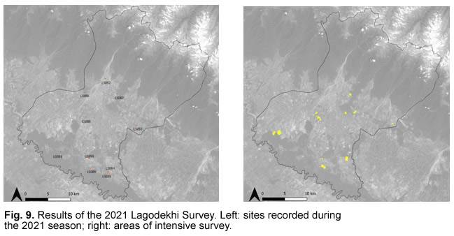
In order to supplement the data collected during the 2018 and 2019 expeditions, the main tasks for this year were to undertake further intensive survey transects in different environmental zones of the Municipality, to continue checking the topographic features recorded by Remote Sensing and those tracked from the old Soviet Map and the National Heritage Database of Georgia (Memkvidreoba). Generally, ground visibility was expected to be optimal during this period of the year, as proved during the 2019 survey expedition. Nevertheless, because of the very unstable weather conditions of the previous month, some southern parts of the Municipality were not practicable and the day-by-day selection of areas depended on their accessibility. For this reason, the first days of expedition were dedicated to the upper valley, where rainwater drained faster, and the last ones to the lowland forest, which was still partially flooded. Survey transects were conducted on recently ploughed uncultivated fields. Individuals were spaced approximately 10 m apart, and all artefacts were collected for each 50 m area. Where visibility was scarce because of the presence of cultivation or grassland, a topographically informed survey methodology was used in which individuals spaced approximately 10 m apart covered the accessible landforms and recorded any sites or finds as waypoints (WP) with a GPS. Scattered artefacts were collected in order to understand the period of frequentation of each site. The survey allowed to add 10 new sites (LS084-LS093) and several other possible locations of ancient activities. Fig.9 shows the totality of sites recorded in 2021 (left) and the areas subjected to intensive survey (right).
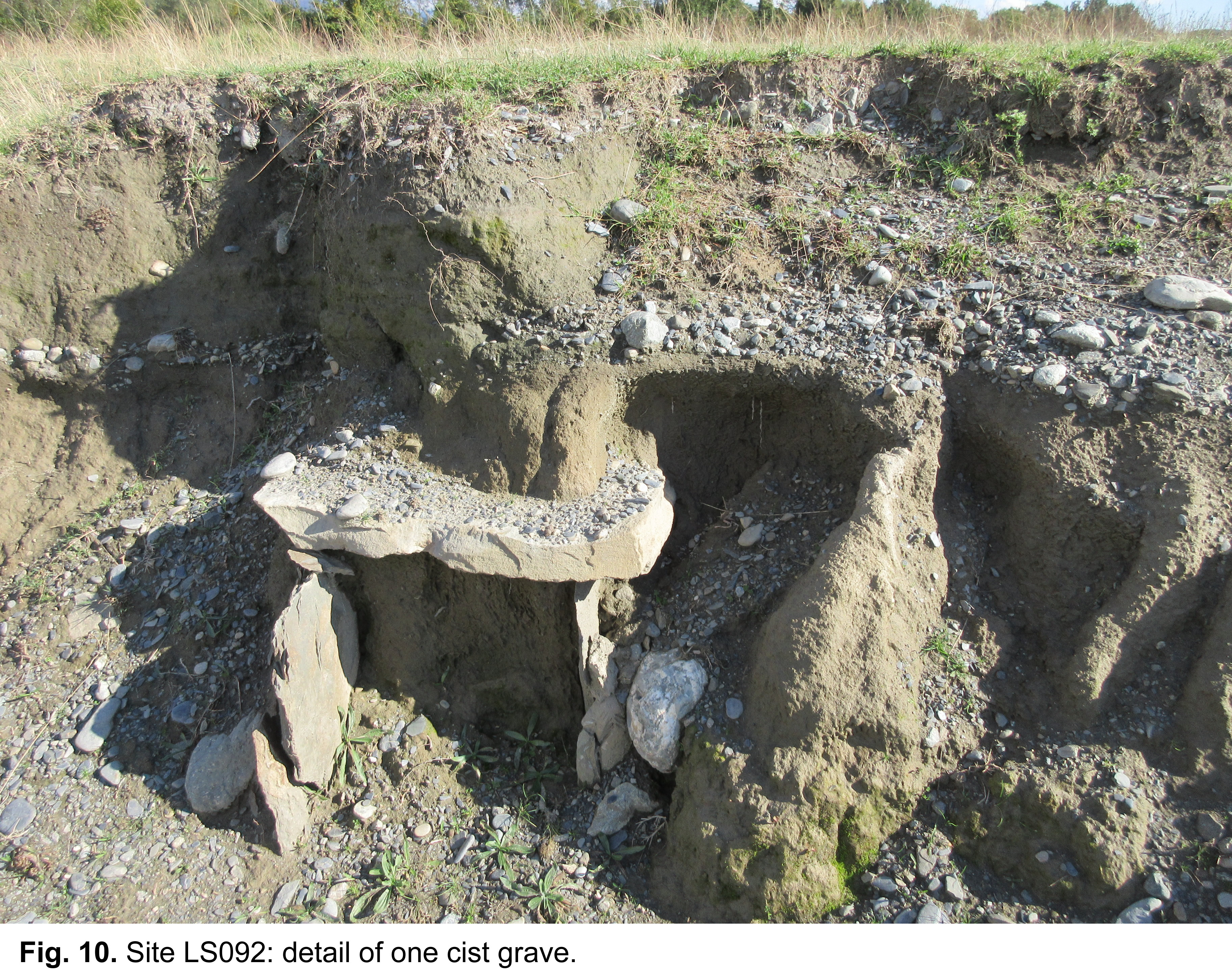
Among the sites recorded in the uplands, especially worth mentioning is an early medieval cemetery situated between the Kabali Tati River and Uzuntala (LS092), at a location where the discovery of four cist graves after a recent earthmoving caused by heavy and abundant rains was reported by local villagers ( Fig. 10). To judge from the building technique, the tombs are probably to be dated to the 6th or 7th century AD. Considering the high risk of destruction of the site and the importance of the discovery, the Cultural Heritage Ministry is initiating emergence excavation of the area.
In the intermediate section of the valley, intensive survey was conducted on fields in the area of Karsubani, where the visibility was generally good, except for some brushwood covering the plough furrows. Besides that, close to Davitiani village, 2 km west of the border with Azerbaijan, we checked the location of a ruined church dated to the Medieval Age (12th Century AD) (site LS085) whose presence had been recorded in the National Heritage Database.
The lower part of the valley, both north and south of the villages of Ulianovka and Heretiskari, was another focus of investigation. The areas NE of Ulianovka and NE of Heretiskari were selected to be object of intensive survey for the optimal visibility caused by recent ploughing. Among the most interesting results in this area is also the discovery, following the indications of local informants, of a multiperiod mound situated to the south of Ulianovka (LS084) with material scattered all over the top and the perimeter. The fragments of recovered pottery were of different periods (Chalcolithic, Middle/Late Bronze, Iron and Medieval Age); obsidian was also abundant. The diameter of the mound measures approximately 150 m. Approximately 200 m south of this site, another cluster of artefacts was recorded (site LS093) on the embankment of a recently excavated canal. The assemblage collected here is composed of few Chalcolithic sherds, Middle and Late Bronze Age pottery fragments, numerous fragments of obsidian and daub. The original extent of the site cannot be precisely estimated because of the modern damages.
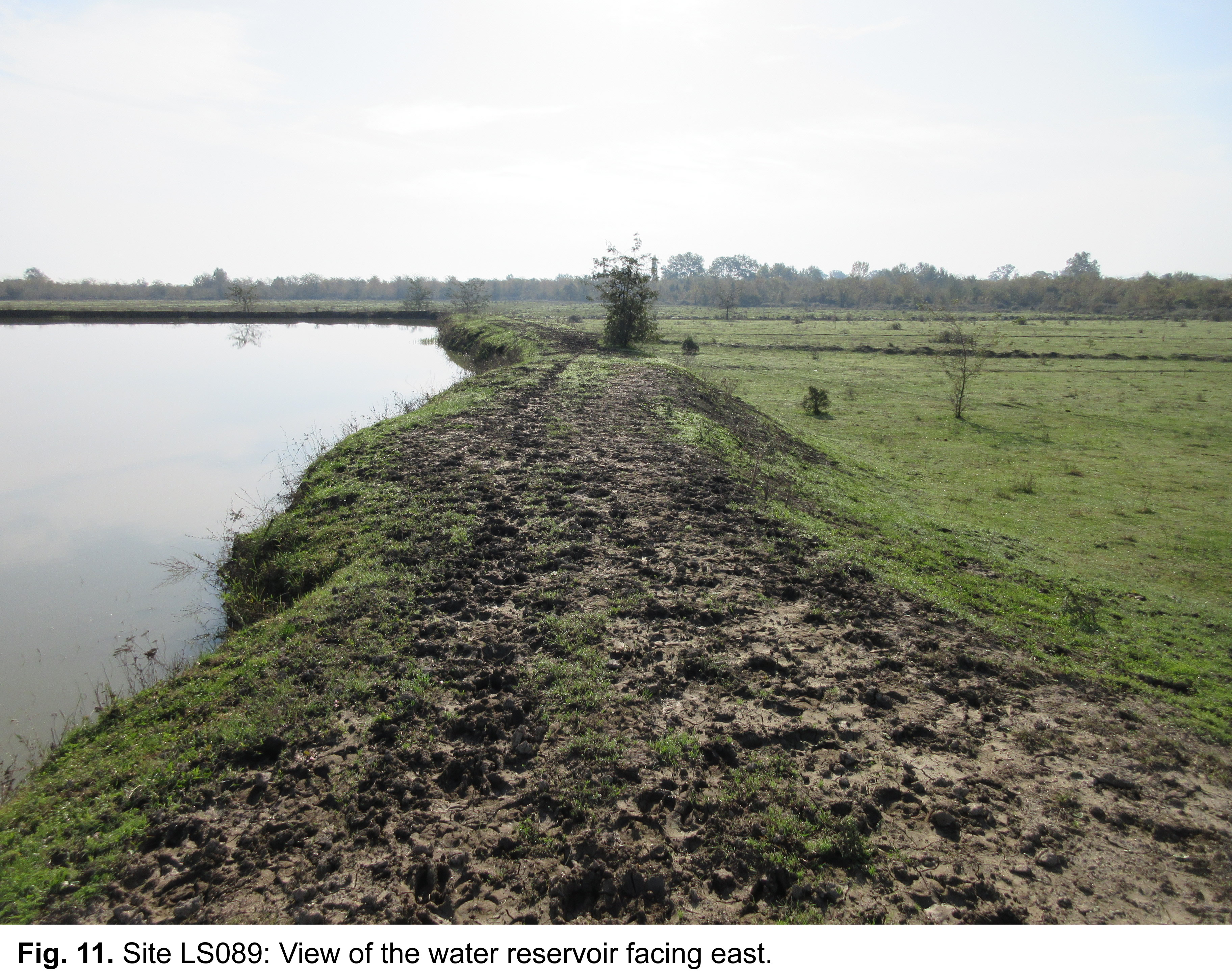
South-east of Heretiskari, in an area presently occupied by two water reservoirs, Soviet maps recorded the presence of three mounds, possible kurgans, set in the swamp joining the low valley woodland. Here, on the south-eastern and north-eastern embankments of the reservoirs, we collected several obsidian and pottery fragments (mostly dated to the Middle Bronze and Iron Age) (site LS089) (Fig. 11). This material may prove the presence of the mounds indicated on the Soviet map, which were probably destroyed by recent human activities.
As for the lowland forest, its investigation this year was hindered by the heavy rains, which caused the flooding of a large part of it. In spite of this, we managed to verify the presence, close to the Areshi River, of a kurgan (site LS091) indicated on the old Soviet Map as a raised mound. As visible on CORONA imagery, this feature was located in a once cultivated area, which now appears mostly abandoned and used for grazing and to collect wood. The barrow, which is ca 3 m high and whose diameter ranges approximately around 25 m, was damaged both on the perimeter, by modern ploughing, and on the top, by probable looting.
Overall, the 2021 results confirmed the ancient occupational pattern of the territory that was recognised during the firsts survey seasons: the earliest frequentations, from the Chalcolithic to the Bronze Age, concentrate in the lowlands in the southern part of the municipality, while the medium valley shows more sites dated from the Late Bronze Age to the Hellenistic period, and the uplands more Medieval sites. This general pattern and the conditions of the recorded sites show how deeply recent human activity has impacted on the visibility and preservation of the archaeological features.