INVESTIGATIONS AT TSITELI GOREBI 5
Geomagnetic prospection
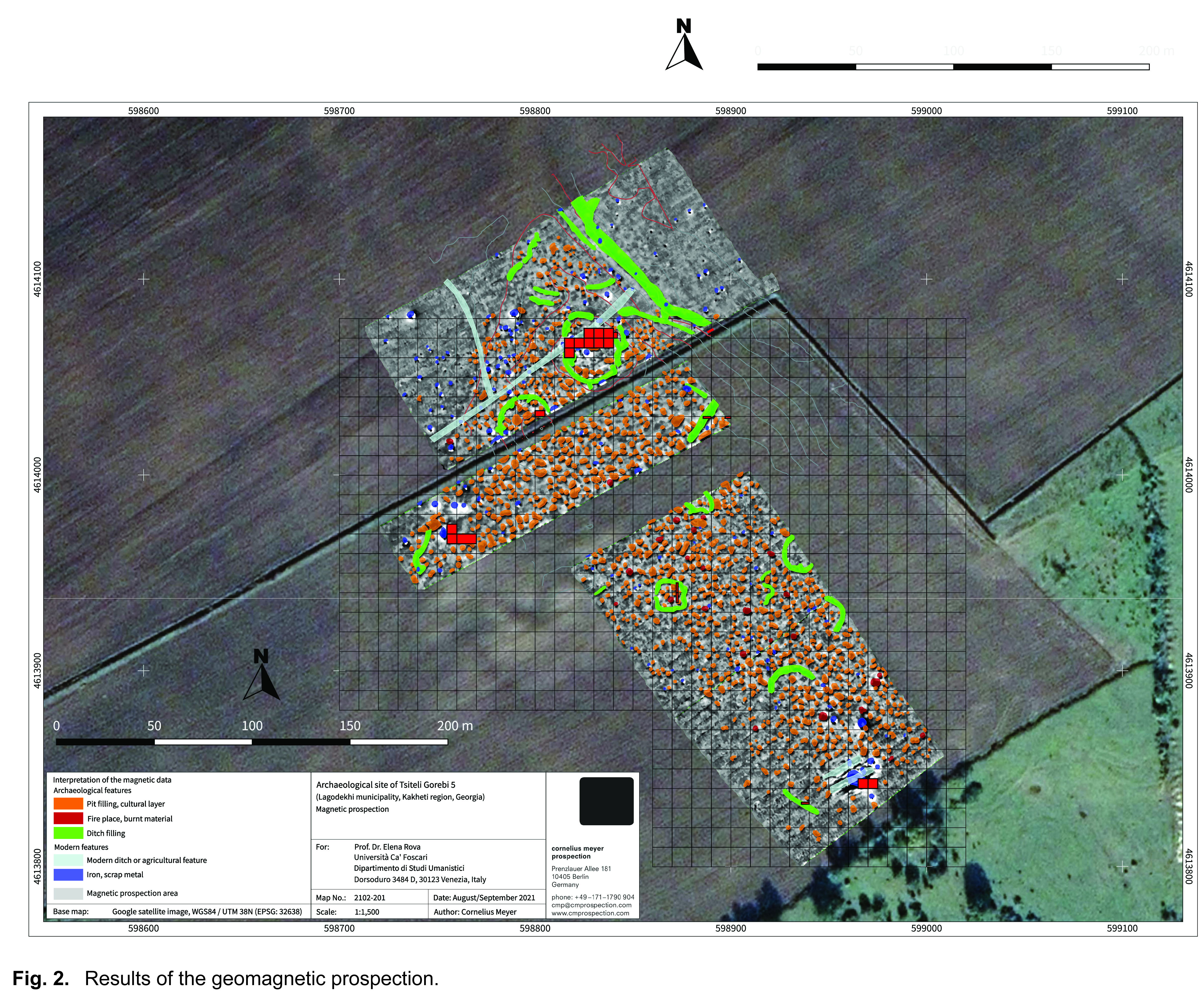
The excavations at the site were preceded by a short magnetic prospection (August 29th-September 3rd) carried out by Cornelius Meyer (Cmprospection Berlin, Germany) with the assistance of Margherita Carletti. During the one-week survey campaign a total surface of approximately 4.2 ha was investigated by use of the MXPDA 5Kanal ARCH magnetic gradiometer array from the German manufacturer SENSYS (Fig.2). This system was configured with five fluxgate gradiometer probes, mounted on a small cart, and a RTK-GPS with base and rover.
The surface conditions of the cultivated but harvested fields were sufficiently good with some deep plough marks and a moderate amount of sources of disturbance. Some slight elevations and the remains of an old river terrace can be observed in the terrain. The magnetic data show some striking linear structures of positive magnetisation, indicating the fillings of prehistoric ditches. Surprisingly, the fillings of modern canals, dug out in Soviet times and discovered in previous archaeological excavations, although some of them were put into evidence by the prospection, are not showing high magnetic intensities. This can be explained with the short period of existence of these canals and a filling lacking of organic content and other potentially ferromagnetic material. The wide linear structure observed in the northeast is most likely related to the old river terrace on which the prehistoric settlement had emerged, whose limit was somehow repeatedly modified by human intervention. Most interesting are circular and semicircular features inside the assumed settlement area, one of which continues the line of the Chalcolithic ditch discovered in 2019. It can thus be hypothesised that they mark similar internal delimitations within the settled areas.
The most striking result of the prospection is the discovery, all over the slightly elevated areas, of numerous and densely arranged circular and oval positive anomalies with diameters of 1 to 4 m. On the other hand, the flat zones, covered in the northern and southwestern prospection area, lack any significant magnetic anomalies, indicating a more or less homogeneous ground. When interpolating between the three investigated areas under consideration of the topography, this strong dichotomy suggests an area of about 5 to 6 hectares, i.e. much larger than previously assumed, for the extension of the settlement area. The nature of the small circular and oval positive anomalies cannot be established only on the basis of the magnetic prospection: they could in fact represent settlement remains such as pit houses, storage pits and post-holes, or be related to firing installations such as domestic hearths or furnaces. Previous archaeological excavations (in 2018 and 2019) confirmed the existence of several large pits, dug out in Soviet times, interfering with the prehistoric structures. However, it can be assumed that these modern features have only a minor impact on the magnetic data, as seen at the modern canal found in the Northern part of the investigated area.
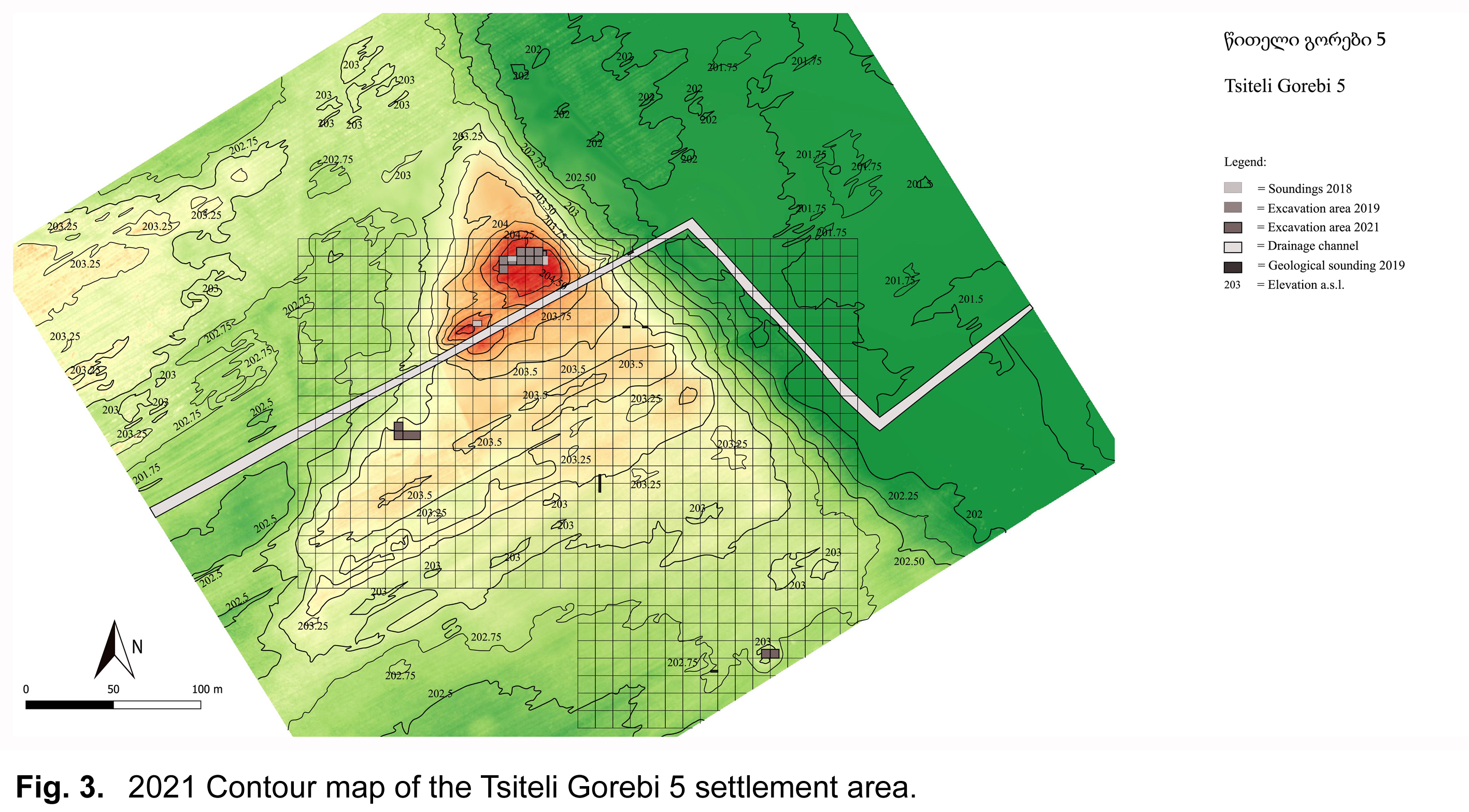
New contour map of the site
Geological soundings
In order to clarify the depth, character and origin of the structures recognised by the geomagnetic prospection, five small test trenches were opened, during the last two weeks of the excavation, in areas where intensive survey carried out in 2021 had not highlighted the presence of archaeological materials.
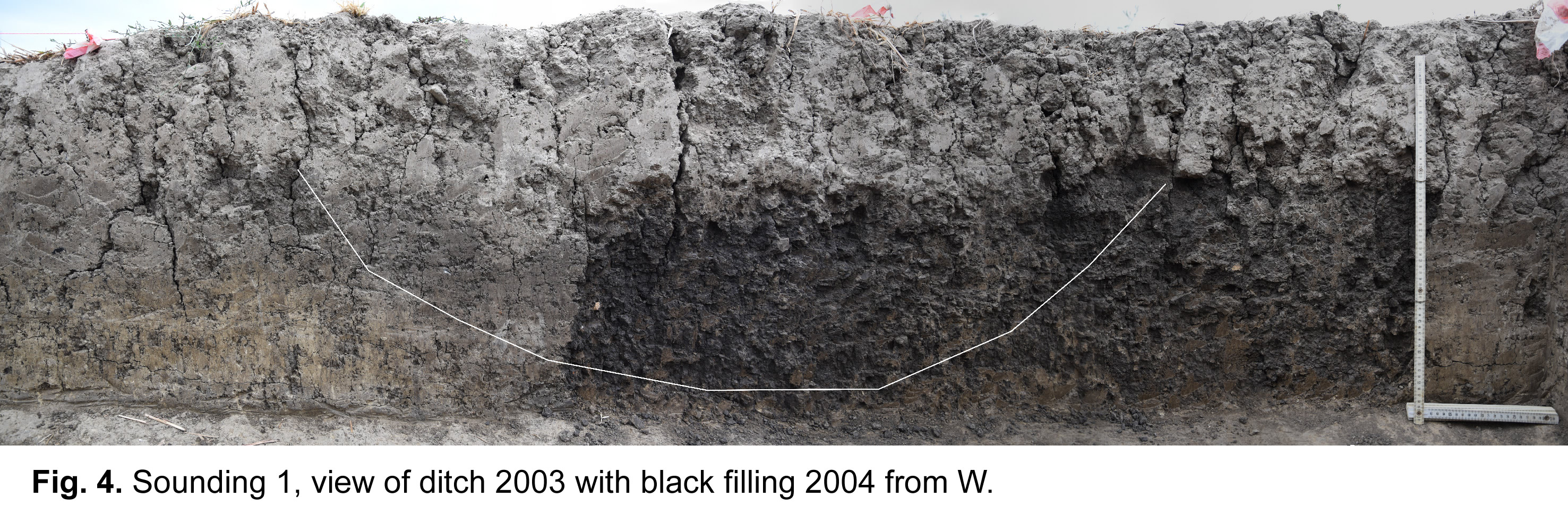
Sounding No. 1, in the centre of the prospected area, approximately at midway between excavation areas B and C, extended for 10 x 1 m along a NS axis. It confirmed the presence of the ditch of sub-circular shape with a diameter of about 15 meters identified by the geomagnetic prospection, which was intercepted close to its northern limit (Fig. 4). Only the bottom of the ditch (locus 3003) was preserved: it was filled with a very compact black layer (locus 3004), whose colour is probably the result of organic decomposition. Some ceramic sherds, two obsidian fragments and 10-15 fragments of animal bones were found inside it.
Sounding 2, located to the south of the modern canalisation which cuts the archaeological site, confirmed the existence and the Chalcolithic date of the large rectilinear ditch visible in Fig. 2 just to the north of the ploughed field. Similar to the previous one, only the bottom of this ditch (locus 4003) was preserved (it had a maximal depth of 22 cm). It was also filled with dark soil, which yielded two Chalcolithic sherds and small fragments of daub. The layer in which the ditch was cut was underlain by a layer of yellowish sediments with calcium carbonate inclusions (locus 4005) which was cut by two pits (loci 4006, 4007) filled with dark brown soil containing some animal bones. Several fragments of Chalcolithic (?) ceramics, animal bones, daub and fragments of obsidian were collected from this layer and from the lower part of the sounding, which undoubtedly predates the Chalcolitic ditch. Excavation continued on a small part of the trench until reaching a depth of 2.56 m, encountering only levels of alluvial natural origin.
Sounding 3, measuring 1 x 5 m, was opened close to the southern limit of the site, near excavation area C. Again, it confirmed the presence of the bottom of the curved ditch highlighted in this area by the geomagnetic prospection. Unfortunately, neither pottery nor lithics were recovered from its filling. A similar situation characterised the underlying layers, which did not contain any artefacts and were probably of natural. They were excavated on a limited area until a depth of 2.40 m from the surface. Just above this point, however, a small portion of a pit could be be seen in the section of the sounding.
Two similar pits, one of which was cutting the other one, were also discovered in Sounding 4, a small trench of 3 x 1 m located a few meters to the east of Sounding 2, at a point where the prospection had not suggested the presence of any Chalcolithic ditch.
To sum up, Sounding 1-4 confirmed that the ditches put into evidence by the prospection belong to the same phase as the Chalcolithic remains excavated in 2018-2019, and that the extensive network of pits highlighted by the same prospection are undoubtedly earlier than this phase.
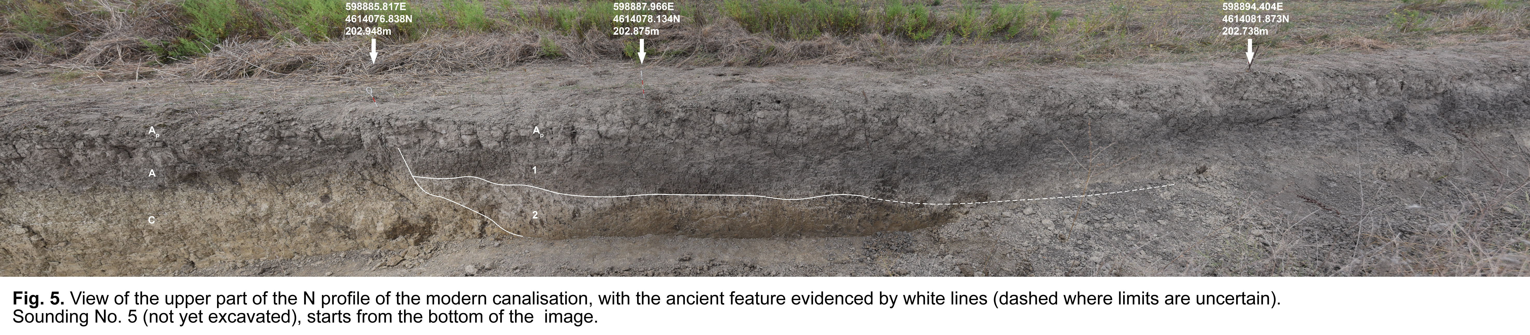
A last sounding, No. 5 (Fig. 5), was opened at the NE limit of the ancient settlement, at the point where the modern canalisation meets the large rectilinear feature running in NE-SW direction made visible by the geomagnetic prospection, in order to ascertain the nature of the latter (large ditch, or edge of the natural river terrace marking the settlement’s limit?). The sounding (which measured 3.50 m x 1.5 m) took advantage of the N section of the modern canalisation, and reached a depth of 2.90 cm from the present surface. It suggested that the limit of the ancient terrace had indeed been repeatedly cut by a human-made ditch, into which material of anthropic origin was deposited at different times within the Chalcolithic period. The different layers of the filling yielded pottery sherds, obsidian fragments and animal bones.
Excavations
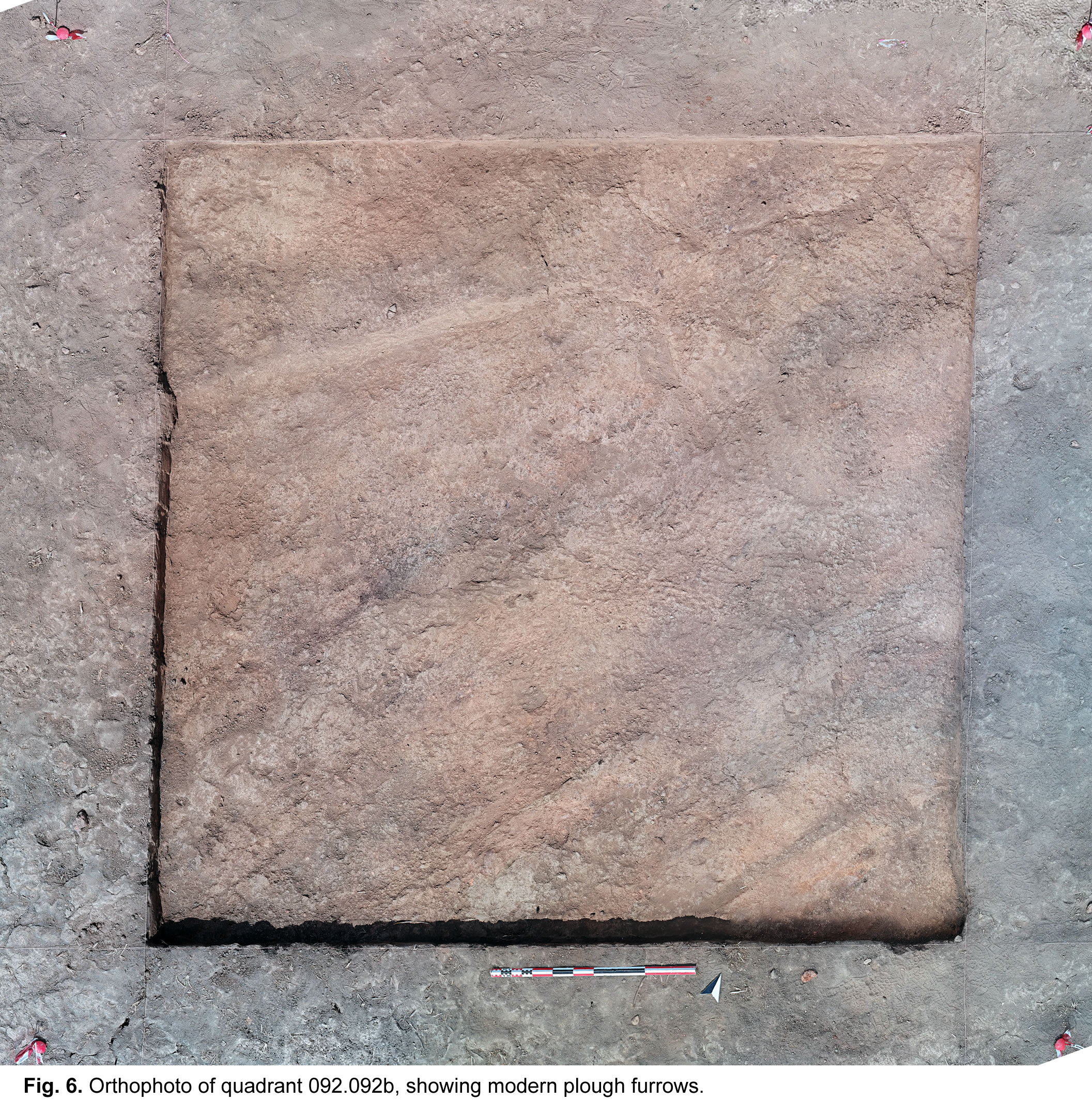
This year’s excavations aimed at verifying the presence of occupation (contemporary to the one unearthed in 2019) in the southern part of the site, where surface investigations carried out in fall 2019 had put into evidence two concentrations of Chalcolithic pottery, obsidian and reddish clayish material (daub).Field B is located close to the modern canalisation, ca 100 m to the SW of the area investigated in 2019. It consists of a very low mounded area of ca 20 m in diameter, marked by a surface concentration of reddish daub, obsidian and Chalcolithic pottery sherds. Two 5 x 5 m quadrants oriented in NS direction (092.093d-092.092b) were opened there at the beginning of the season. The archaeological sequence highlighted in these quadrants is comprised within the first 50 cm from the present surface. From a general standpoint, the stratigraphy of the area seems quite uniform: the first 20 centimetres comprise a layer heavily disturbed by agricultural activities (repeated ploughing) (Fig. 6). After its removal, all the surface, excluding the southeast corner, is covered by a compact grey/greenish layer. This may represent the equivalent of the raised “platform” on which the structures excavated in 2019 to the north of the modern canalisation were built but, if this were indeed the case, nothing would be preserved of the overlying Chalcolithic structures except for the scattered surface material. In the same area, however, we should highlight the presence of a cub-circular area occupied by a set of reddish/brownish burnt layers. This succession, that probably needs to be dated to the Chalcolithic period, has been heavily interfered with by modern agricultural activities, and its interpretation is unclear, although it was obviously related to the use of fire.
All these traces of activity lie on top of a sequence of fine alluvial deposits, which was excavated down to a depth of nearly two meters in two different deep soundings without finding any significant sign of human activity, but occasionally encountering small isolated artefacts, which can be interpreted as overbank fillings of a naturally depressed basin. The sequence highlighted by the exposed sections shows that these deep deposits were altered by pedogenesis, as shown by the formation of specific soil horizons such as the calcic one. In other words, the anthropic occupation on top of the sequence took place during a phase of alluvial stability. Radiocarbon dates coming from the collected samples of rare charcoals may allow us to chronologically fix the starting phase of the anthropic occupation, thus giving us the possibility to better interpret the described archaeological remains.
During the last weeks of work, the excavation was expanded, in eastern direction, by opening two additional quadrants (093.092b-d) in the hope to be able to reach the level of the pits highlighted by the geomagnetic prospection, which appeared especially frequent in this area, over a larger surface. In these eastern quadrants, no traces of the yellowish compact layer were present but, in their western part at least, the layer of reddish burnt debris continued. East of this, only a sequence of natural layers and no rounded pits were unearthed, although the bottom of two successive ditches filled with dark soil cutting them was also encountered. This may support the conclusion, drawn from the geological soundings, that the round-shaped anomalies highlighted by the geomagnetic prospection belong to a phase earlier than the Earlier Chalcolithic settlement. Unfortunately, excavation had to be suspended for several days due to the heavy rain which affected the Lagodekhi region at the beginning of October. This fact hindered us to reach the depth at which some pits had turned out in the geological trenches elsewhere and thus made it impossible to verify the hypothesis for the Field B area.
In conclusion, the excavated area had indeed been a small raised mound, seat of human activities during the Early Chalcolithic period, contemporary to the area excavated in 2019, but modern mechanical agriculture had completely obliterated all remains of these activities, leaving only a scatter of surface material on the spot. On the other hand, the presence of out of context artefacts in natural layers under the base of the Chalcolithic settlement and the round features put into evidence by the geomagnetic prospection, none of which was found in the course of the excavation, suggest the presence in the area of earlier human occupation.
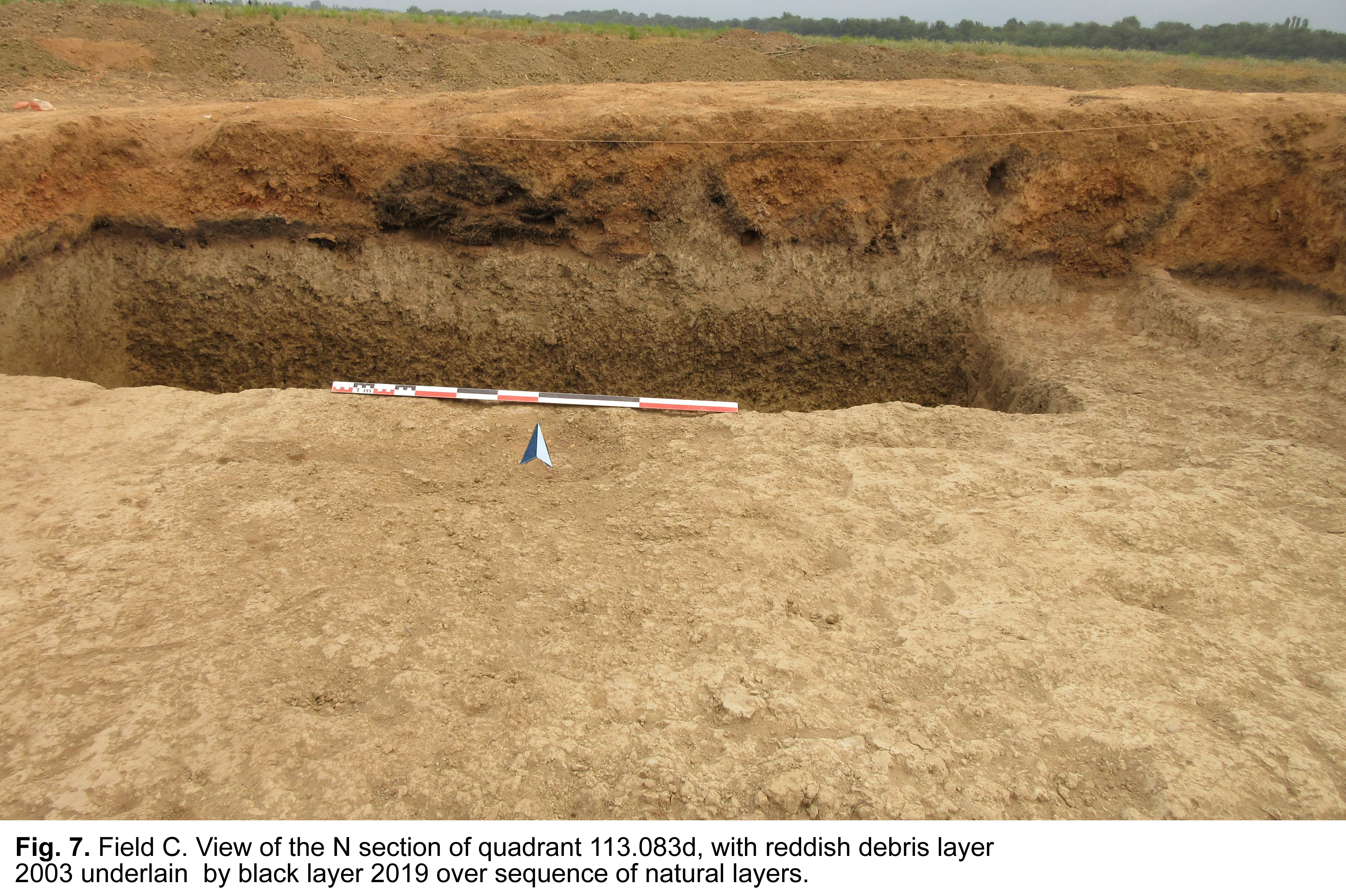
Field C is located ca 250 m to the SE of the main Tsiteli Gorebi 5 mounded area, on a low isolated mound (appr. 20 meters in diameter, ca 1 m high). This had been already observed during the 2018 survey, and tentatively identified, at that time, as a possible kurgan (site LS023). A new visit in the course of the 2019 survey season, when visibility conditions were much better, had highlighted the presence, on it, of abundant Chalcolithic pottery, obsidian and of a large amount of burnt reddish “daub”. Two 5 x 5 m quadrants oriented in EW direction (113.083d-114.083c) were thus opened on top of it, in the hope to encounter a less damaged area of the Chalcolithic settlement. Here, under the plough soil, however, excavation put into light only a 30-50 cm thick very irregular layer of reddish debris (locus 2003) filling some depressed areas of vey irregular shape dug into the natural soil. This extended all over the excavation area, and was underlain by a black burnt layer of varying depth (locus 2019) (Fig. 7). The reddish layer yielded very scarce finds (a few obsidian flakes, almost no pottery sherds or animal bones) and is therefore of uncertain interpretation. One possibility is that it originated from the repeated destruction of temporary firing installations, which lay directly over the ancient natural soil. Different hypotheses, e.g. that it represent the results of “slash and burn” forest clearing or similar practices, cannot be excluded, either.
Under the black burnt layer, a sequence of layers of probably natural origin was unearthed, some of which however contained sparse artefacts (mainly obsidian fragments, but also a few Chalcolithic pottery sherds). This suggests that earlier anthropic layers are indeed present in the nearby area. Excavation continued, on a limited surface (two-1m wide soundings), until reaching a depth of 1.40m, without encountering any other sign of human activity besides these sparse artefacts.
Artefacts and ecofacts
As anticipated, artefacts from this season were extremely scanty, and most of them came from the plough-disturbed surface soil. They were for the most part extremely fragmentary and in poor state of preservation, and did not differ much from those uncovered during the past seasons.Ceramics (processed by Vanessa Perissinotto) amounted only to 116 sherds, only 15 of which (12.93% of the total) were diagnostics. They were very similar to those discovered during the previous campaigns, and were divided into the same fabric groups (LBOW, 50 sherds, 43.10%, GW, 17 sherds, 14,65% and RW, 13 sherds, 11.20%). As far as it can be judged, the repertoire of shapes and decoration is the same as that of the previous years. Maybe due to the extremely low number and bad state of preservation, it was impossible to detect any difference between the pottery from the main Chalcolithic occupation and that from the underlying layer of pits. Chipped lithic were analysed by Flavia Amato. The assemblage included 41 tools (40 of obsidian and 1 in chert) and 167 debitage elements (all made of obsidian). Among the debitage elements it was possible to distinguish 50 debris, 108 chips, 251 flakelets, 136 flakes, 11 bladelets, 13 blades and 3 primary elements, while tools are represented by 1 flint flake tool and 40 obsidian tools, subdivided into 21 blades tools, 8 flake tools, 3 scrapers, 1 arrowhead, 1 bladelet, 5 cores, and 1 drill. It is interesting to observe that some of them came from the pits related to the earlier Chalcolithic occupation.
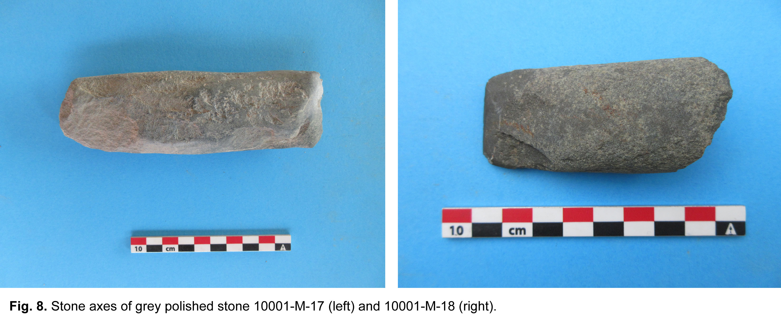
Contrary to the previous years, no bone tools were unearthed this year. On the other hand, some interesting finds were made in the field of macrolithics. These were mostly discovered during surface collection in the recently ploughed fields next to the excavation areas. They allowed to widen the morphological repertoire of macrolithic tools from the site to hitherto unattested types: especially noteworthy are three fragments of very large grinding stones and two small axes of grey polished stone (Fig. 8). Similar objects were previously found by V. Varazashvili at other sites of the Tsiteli Gorebi cluster; some of them are presently exhibited at the Sighnaghi Museum.
Animal bones, studied by Giovanni Siracusano, were equally rare and poorly preserved. Nearly all of them (ca 98%) belonged to domestic species (mainly ovicaprines and bovines). Of these, about 50% belonged to caprines, 30% to cattle, 5% to pigs, 5% to dogs, 1% to equidae. Among the wild animals there is a fragment of deer, a fragment of a turtle, three fragments of a rodent (perhaps a vole) and two remains of snails. One of the fragments of a metapodial could, given its large size, belong to a Uro. It was difficult to determine whether some of the breakages were due to slaughter or to extensive fragmentation. However, no fragments bore any cuts. Two bovine bone fragments had traces of burning, while only one had traces of gnawing.