(Giovani Boschian))
Tsiteli Gorebi 5. Preliminary geoarchaeological notes
The geological and geoarchaeological sequence of the Tsiteli Gorebi 5 site is located in the alluvial plain of the Alazani river and of its tributary Kviriatskhali, which flows few hundred metres to the east of the site. The area is subhorizontal for some kilometres around the site, with minor undulations that are unlikely to be the result of past river processes, because of the typical meander-like fluvial régime of the rivers. Conversely, extensive land modifications carried out in the last 80 years for crop agriculture improvement erased part of the original geomorphologial imprint of the rivers on the landscape.
The sediments observed in the surroundings of the site, in archaeological soundings or along deep field drainage channels, are mainly silts, silty loams and clay loams, with occasional sand intercalations. The soils observed are mostly recent Entisols developed at the surface of the aforementioned sediments, and are largely disturbed by modern ploughing. The water table is shallow, deriving from river losses and from inputs provided by the rich water table of the alluvial fans that border the Caucasus fringe. Oscillations of the water table are originating redoximorphic features in the sediments below 1.0-1.5 m.
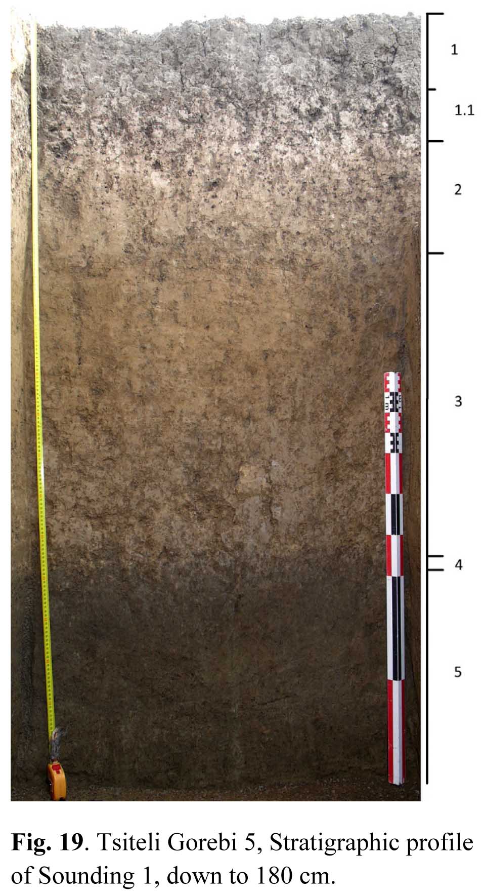
The sequence better showing the general stratigraphy of the site was found in Sounding 1 (Fig. 19). The following layers were observed from top downwards.
1. Brown-dark greyish silty loam or silty clay loam, with well developed medium to coarse granular aggregation; no skeleton. Abrupt, horizontal and locally undulating limit; thickness 0-33 cm. The hue is lighter and the aggregation is somewhat poorly developed in the lower 15 cm (1.1) of this unit.
2. Brownish clay loam or silty clay loam, rather compact (mostly when dry), moderately developed fine to medium granular aggregation. No skeleton. Very common dark and light mottles, vertically elongated and subcircular in the horizontal plane, produced by earthworm activity throughout the unit. Clear subhorizontal limit. Thickness 33-60 cm.
3. Light brown loam (lighter at the base), homogeneous, soft, massive or with rare areas of medium developed fine to medium granular aggregation in earthworm burrows. No skeleton. Abrupt, subhorizontal and plane limit. Thickness 60-138 cm.
4. Thin discontinuous level (0-4 cm) of disconnected whitish clay clods, locally eroded. Marks the limit between 3 and 5.
5. Greyish brown or seldom greenish (darker at top) sandy loam-very fine loamy sand, soft, no sedimentary structures, massive. No skeleton. Common oxidised redoximorphic features (brownish Fe-oxide mottles). Sharp subhorizontal limit. Thickness 140-260 cm.
6. Dark grey fine to medium sand, with whitish granules. Very homogeneous, soft and without sedimentary structures. Limit unobserved. Thickness 260-285+.
Observations carried out along the channel situated few metres south of the site put into evidence a sequence that resembles the aforementioned one, but also presents remarkable differences. The top unit is a dark grey-blackish soil A horizon, whose top 25 cm are disturbed by ploughing. This horizon grades downwards into a C horizon resembling unit 3 but with a slightly higher chroma, including more frequent redoximorphic features and common very altered whitish CaCO3 mottles. It must be pointed out that the oscillations of the water table affect more strongly this sequence, as its top level is about 1 m lower than the top of the mound. It can be hypothesised that unit 2 of sondage 1 represents an anthropic unit deriving from still unspecified human activities. However, the about 30 cm of this unit do not fully account for the difference in height between the mound and the surrounding plain. More soundings and sequence observations will be necessary in order to better understand the site formation processes and their relationships with the surrounding river system.
Geomorphology of the Lagodekhi area (Fig. 20)
The geomorphological study of the survey area was carried out mostly on cartography and satellite images, with some terrain check. The cartography employed is in fact the DTM derived from 1 arcsec SRTM data (freely available through the US Geological Survey) and the 10, 20 and 60 m resolution multispectral Sentinel 2A images provided by the European Space agency (images 09.10.2017; 19.10.2017; 13.12.2017; 02.01.2018). The data used were True Colour images, false colour images (bands 12, 11, 8) and NDVI data (bands 3 and 8A). Rather unsurprisingly the October and December images provided higher quality data, as ploughing is carried out mostly in that period in the Lagodekhi area. Terrain checks were carried out during the archaeological survey, mostly caring about the morphological and chromatic elements observed in the cartography. It resulted from field checks that forest areas were mapped as land surface in the SRTM data.
At small scale, the area is characterised by three physiographic elements: the Caucasus fringe reliefs, the Alazani alluvial plain, and the large alluvial fans deposited by the left-side tributaries of the Alazani, which accumulate coarse (and energy-sorted) sediments eroded from the Caucasus reliefs. The Caucasus reliefs were not included within the geomorphological survey, because the archaeological research in the area was concentrated in the territory comprised between the Kviriatskhali to the east, the Alazani to the south, the western parallel delimiting the Lagodekhi alluvial fan to the west and the Lagodekhi town to the north.
The alluvial fans extend for more than 10 km from the valley mouths into the alluvial plain. They were largely stabilised in USSR times, and only occasionally coarse sediments overflow the river beds. Apparently, no prehistoric archaeological sites were observed on the fans, suggesting that they formed in relatively recent times. The alluvial plain is subhorizonal and very wide, suggesting that it formed during a phase of overdeposition controlled by tectonic and eustatic vertical movements. The present-day river beds follow a meander-like path, in accordance with the very gentle dip of the alluvial plain. Several abandoned meanders and longer meandering beds can be observed along the Alazani course.
Abandoned river beds of different types can be observed in the Sentinel 2A images.
• large beds (about 100 m-wide) characterised by dark fine sediment embedding cm-size gravel organised in river bars that can still be observed in the field as topographic highs. These palaeo-beds suggest a braided stream régime, and occur mostly at the extreme fringe of the alluvial fans, indicating a relatively high energy transport.
• large (50-100 m-wide) meandering palaeo-channels, mostly located in the vicinity of the present-day meandering rivers, characterised in the Sentinel images by dark grey to light grey/brown colour.
• narrow palaeo-streams, of dark colour, often with wavy course.
• old agricultural ditches, characterised by dark colour and straight course, generally parallel to present-day ditches.