(by Kristen Hopper and Andrea Titolo)
Introduction
Between the 22nd June and 28th July a landscape survey was undertaken in Lagodekhi Municipality, Kakheti, Georgia. The survey was led by Kristen Hopper (Durham University), assisted by Andrea Titolo (La Sapienza University) in collaboration with Davit Kvavadze (Director of the Lagodekhi Museum) and Elena Rova (Ca’Foscari University of Venice), co-directors of the project. Members of the Ca’ Foscari Team including Laura Tonetto, Anna Chiara Muscogiuri, Andrea Milanese, Francesco Bianchi. Chiara Mariotto and Katia Gavagnin participated in various aspects of the survey, as did Magda Batiashvili and Tamo Bichashvili (Sokhumi State University). For one day, Giorgi Kirkitadze and Nino Pataridze from Ilia State University and Lana Chologauri from Tbilisi State University also participated.
The survey area was defined by the boundaries of Lagodekhi municipality and is roughly 900 km². The border with Azerbaijan formed the E and SE limit of the survey area. The N and NE limits of the municipality are defined by the border with Dagestan located within the Kakheti Caucasus Range of the Caucasus Mountains. To the S and SW the survey area is delimited by the Alazani River, which is the most important watercourse in the region. It originates in the Greater Caucasus Mountains and flows NW to SE along almost the entire length of the Alazani plain (over 100 km).
The survey area covers a diverse range of environmental zones. The forested lower ranges and foothills of Kakheti Caucasus Mountains extend into the survey area, giving way, quite quickly, to the very gently sloping, and heavily cultivated, Alazani Plain. Numerous rivers, originating in the Kakheti Caucasus Range, flow from NE to SW to join the Alazani. These include, from east to west, the Shromishkhevi River, the Lagodekhiskhevi River, the Ninoskhevi River, the Baisubniskhevi River, the Kabali River, the Areshi and the Shorokhevi River. Alluvial fans have formed where these rivers exit the narrow mountain gorges. Furthermore, nearest to the Alazani River (on its left bank) there exists a ca 4-6 km wide belt of dense lowland forest.
The Alazani Plain has been heavily cultivated and irrigated through time. Traces of canal systems dating back to Antiquity have been a source of interest to geographers and archaeologists from the early 20th century (see A. Losaberidze, Remains of Ancient Drains and Canals, Tbilisi, 1938 and, more recently, K. Hopper et al., Landscape Investigations in Georgia, in Sauer et al. The Caspian Gates in the Caucasus from Antiquity to the Age of the Huns and the Middle Ages: The joint Georgian-British Dariali Gorge excavations & surveys of 2013-2016, Forthcoming). Significant changes to the landscape can clearly be traced throughout the second half of the 20th century through comparison of historical and modern satellite images, though they likely already began before this. Like in many other regions of the Southern Caucasus, agricultural intensification throughout the Soviet period (especially collectivised agriculture, deep ploughing, and the construction of irrigation systems) has resulted in a very different landscape from that of the past (see K. Hopper et al., Landscape Archaeology in Southern Caucasia: An Introduction, in Anderson et al. (eds.) Landscape Archaeology in Southern Caucasia: Finding Common Ground in Diverse Environments, Vienna, 2018: 11-22; Lindsay et al. Progress, problems, and possibilities of GIS in the South Caucasus: an international workshop summary, Antiquity 92 (362) e9 2018). These factors have significantly affected our ability to read the archaeological record.
Methodology
In order to gain an understanding of the long-term land use history of the region, we employed a methodology that involved both extensive and intensive pedestrian survey.
The extensive survey was guided by published literature, local knowledge and the remote sensing of satellite imagery. Our goal was therefore to visit:
• All sites known from published sources. The descriptions of these sites often lacked detailed location data. Therefore, we aimed to locate as many of these sites as possible.
• Possible sites and features (areas of interest or AOIs) identified through the remote sensing of satellite imagery (modern high resolution imagery available on the Google Earth platform, and CORONA satellite imagery from the 1046 mission from the 18 Mar 1968), and Soviet period 1:25000 topographic maps drawn in the early 1960s and based on aerial photographs from 1954-1955.
• Sites and features described by local residents.
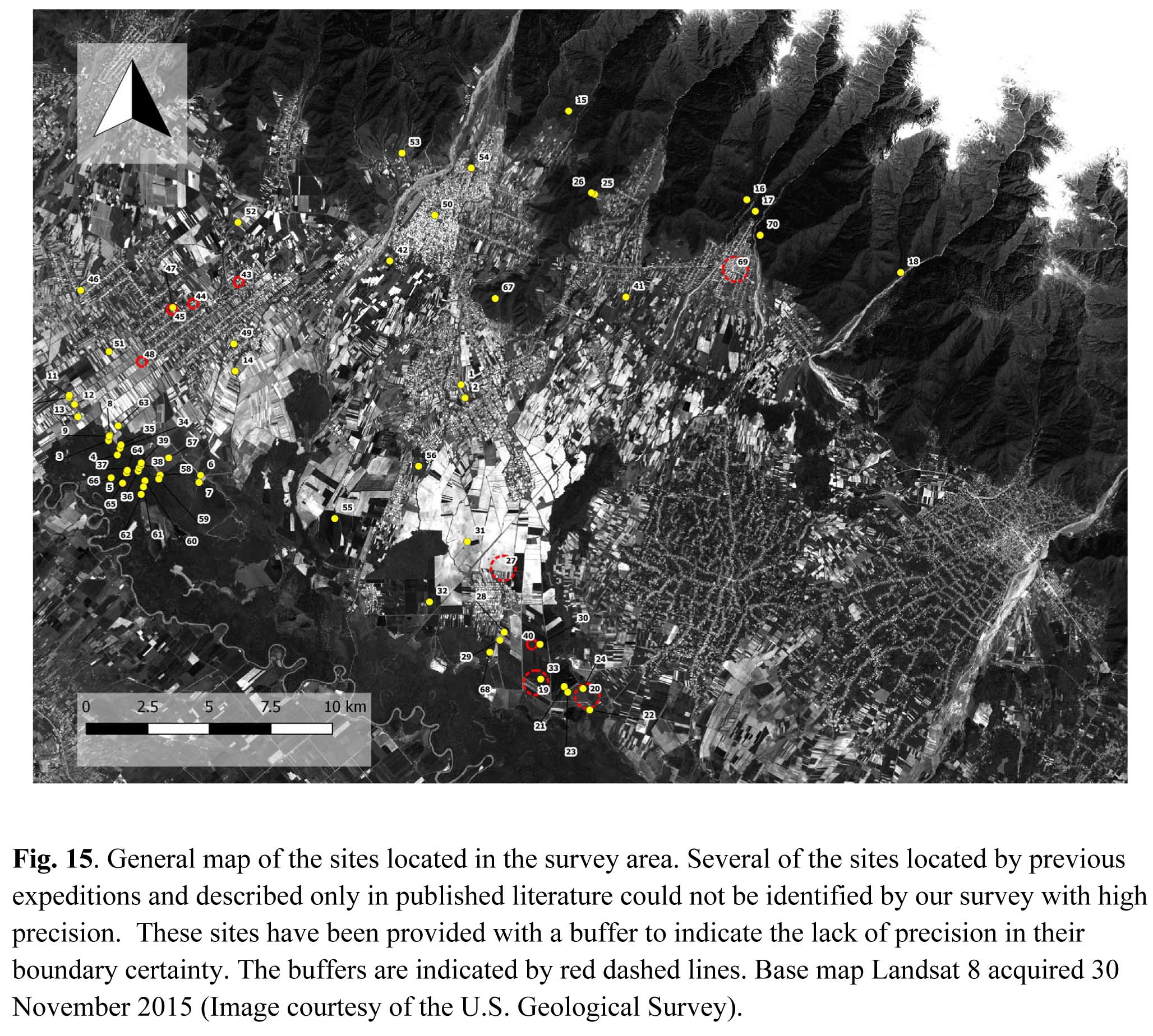
Every site/feature located was recorded and photographed and GPS points were taken (Fig. 15). If present, a representative sample of artefacts was also collected from each location.
We also undertook systematic pedestrian survey in the southeast region of the survey area, near the site chosen for excavation (Tsiteli Gorebi 5 = LS021). We planned the transects so as to intersect with, or pass near known or possible archaeological sites. As ground visibility was poor (see below), we also took the opportunity to undertake some transects in a set of ploughed fields (apparently a rarity this time of year). The transects were oriented N-S. In particular, we wished to see if there was any change in site type or artefact density as one moved across multiple environmental zones (e.g. from the plains toward the forested zone of the Alazani River). Transects of between 500 m and 2.5 km in length and 100 to 200 m in width were surveyed systematically. Surveyors were spaced ca 10 m apart.
A new collection unit was defined every 50 m. Any artefacts found were collected and given a unique number corresponding to their collection unit. We also recorded the condition of the fields that fell into each 50 m collection unit. This included information on the type of vegetation (or crop if under cultivation), the stage of cultivation (if appropriate – i.e. harvested, ploughed), and the ground visibility expressed as a percentage (e.g. 30% of the ground surface is visible) (Fig. 16).
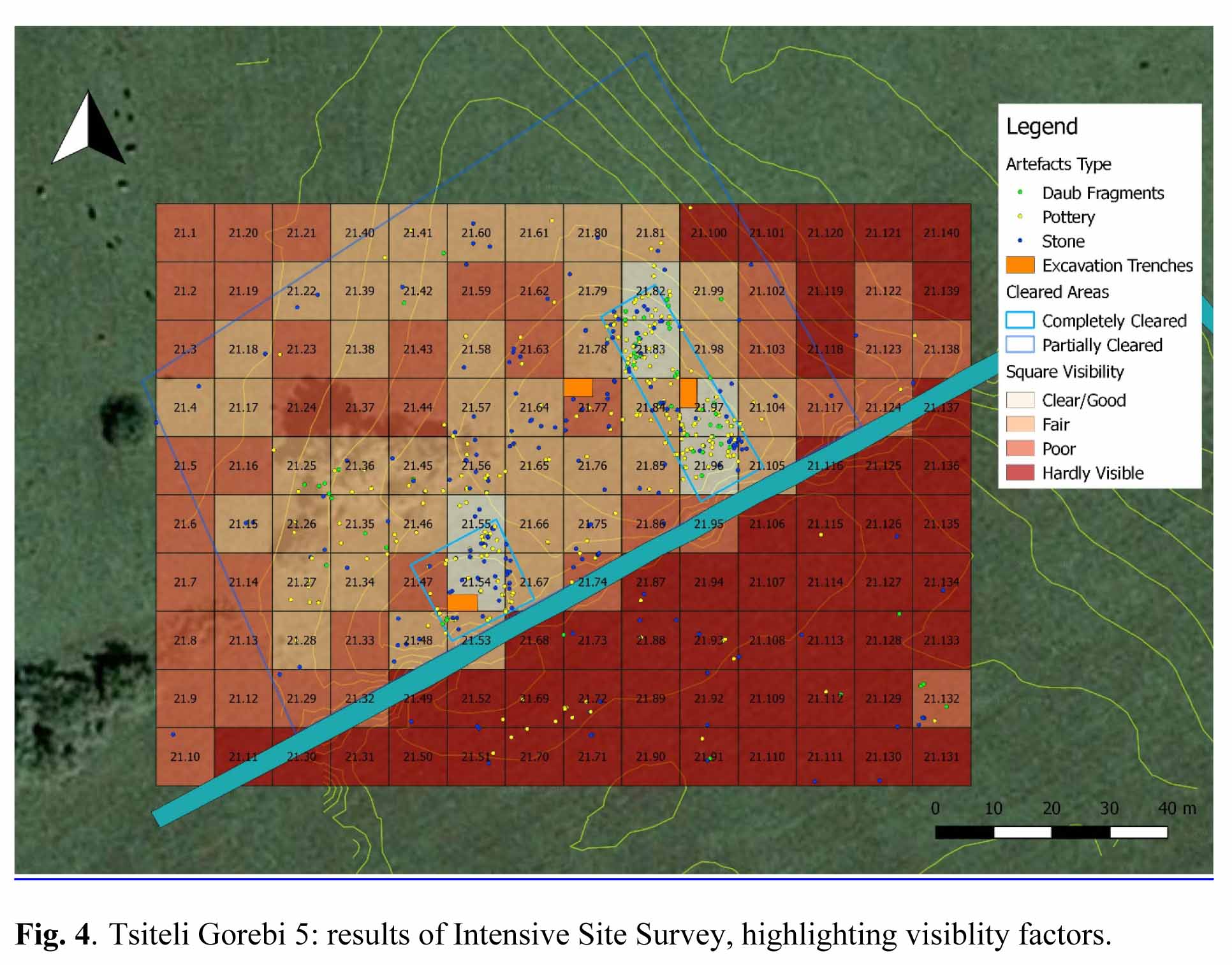
Finally, an intensive surface collection was undertaken at the site of Tsitei Gorebi 5 (LS021) (see Fig. 4, above). This was identified as a Chalcolithic site and chosen for excavation. Our goal was to record artefact distribution over the surface of the site and better define the site area. As such, a collection area was defined taking into account the area of low mounding and extending roughly 25 m beyond in all directions. The location of all artefacts within the area was recorded with a DGPS and their type was noted (e.g. pottery, lithics or daub fragment). Subsequently, all surface artefacts were collected within 10 x 10 m collection units that were laid out using a total station. The ground visibility of each collection unit was also recorded.
Results
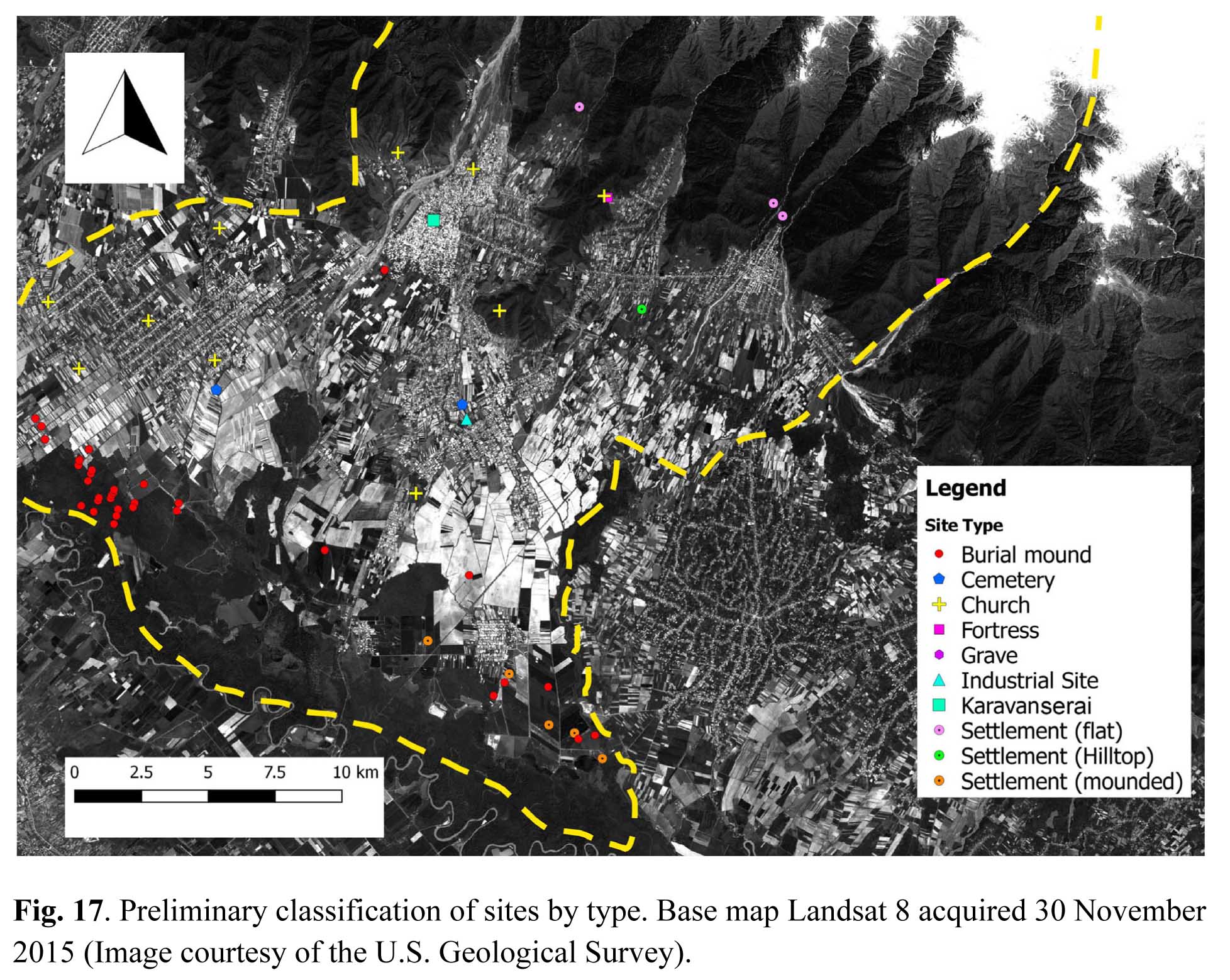
The survey recorded 70 sites over the course of the season (Fig. 17). The sites varied in altitude from ca 200 to ca 700 m a.s.l. and ranged from Medieval churches to low mounded sites that likely represent prehistoric settlements. The majority of sites were located through the extensive survey and it is likely that small sites (e.g. low mounds and artefact scatters) are underrepresented.
We had hoped that the systematic transect survey would help to address this issue. However, ground visibility was poor. Most of the fields in the survey area were still under crop, or had been recently harvested. The recently harvested fields (mostly wheat) often still contained a least 20 cm of ‘stubble’, and were partially overlain by hay. As such, even in recently harvested fields, the average visibility was less than 50% (an often less than 30%). These conditions are clearly reflected in the results of the systematic pedestrian survey in which very few surface artefacts were recorded. However, in several cases, and in particular where ground conditions were more favourable, we were able to locate low mounded sites and artefact scatters.
Some preliminary comments on site types and distributions can be made, though further analysis and research is required. Two low mounded sites, likely dating to the Chalcolithic period, were located in the SE corner of the survey area within 6 km of the Alazani River (LS021, LS033), as was another Chalcolithic site that while now ploughed out was likely originally mounded (LS028). Two further possible Chalcolithic sites known from previous excavations may also have existed at LS022 and LS040, but all traces of them are now gone due to agricultural activity. This was the area in which we undertook the most intensive survey and therefore it may not be surprising that the recovery of features of low topographic relief was more favourable. Despite this, it is possible that Chalcolithic settlement may have been focused on the Alazani River zone. Several palaeochannels of the Alazani River located ca 3-5 km north of its current course could have played a role in settlement location in this period. Intensive survey further to the west along the river zone, and extending north would be useful in clarifying this pattern.
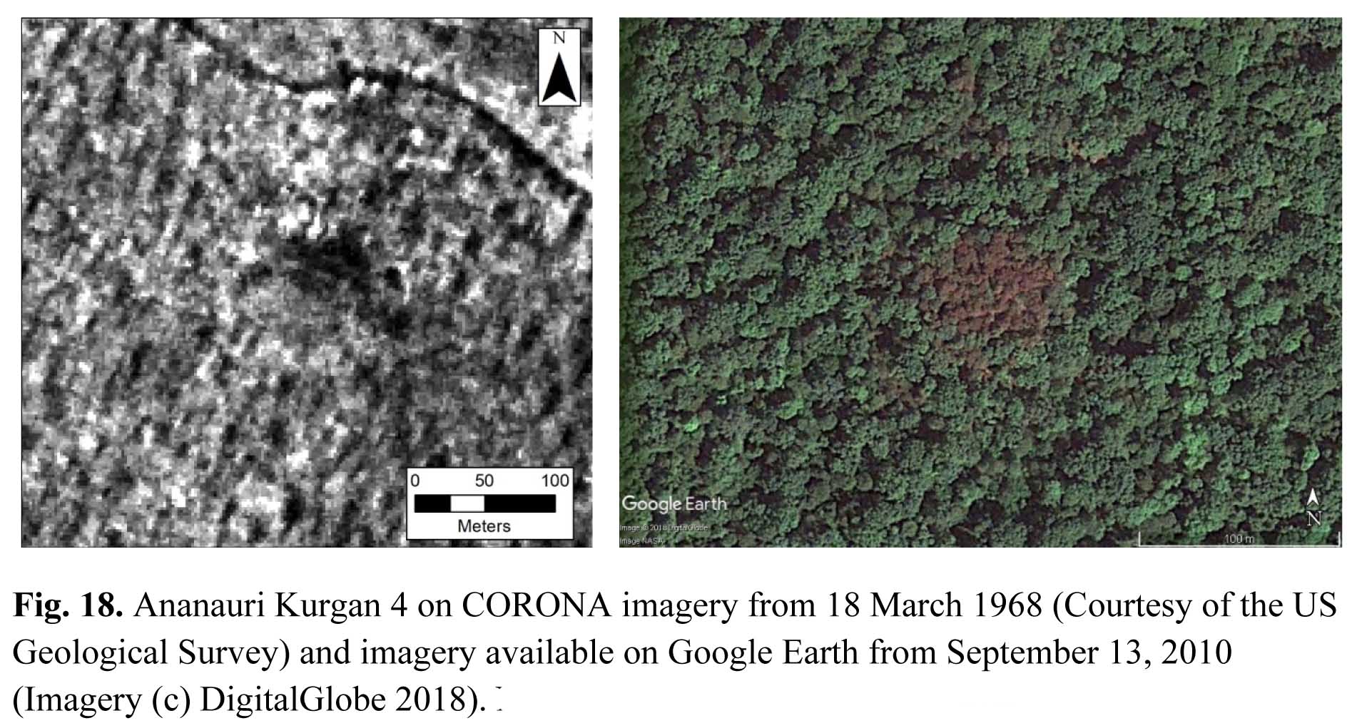
A number of kurgans and possible kurgans (burial mounds) were located within the survey area (Table 1). These kurgans, as in other parts of the regions, appear to date to the Bronze Age, and provide us with evidence of use of this landscape in this period. Several kurgans had been previously investigated (such as the excavated Ananauri 3 Kurgan) and their locations were previously known. Others were located through inspection of Soviet period 1:25 000 maps (drawn from aerial photographs from the 1950s) and the remote sensing of historical and modern satellite imagery. On imagery, kurgans on the cultivated plain either appear as small circular mounds or as areas of vegetation that have been avoided by ploughing. Several locations marked by roughly circular soil discolourations were also located, though it was often difficult to verify if these represented kurgans than had been ploughed out. Kurgans located in forested areas were visible on the modern high resolution imagery because of visible differences in vegetation growth on top of the kurgan. Likely due to their height (c. 1 – 15 m above the surrounding ground level) and the amount of moisture the soil retains, at certain times of year the vegetation growing on top of the kurgans appears brown instead of green (see. Fig. 18).
The majority of the kurgans were found within c. 7 km of the Alazani River; one concentration is located within the forested zone in the northwest part of the survey area, while another group is found in the southeast corner of the survey area near to LS021. A very few examples were found in isolation, such as the well preserved kurgan located just south of the village of Kabali, c. 500 m east of the Kabalitskevi River (and over 15 km NE of the Alazani River). This may suggest that the distribution of such features may have extended farther north in certain locations (e.g. along important NE-SW running valleys that lead into the mountains). The lack of information on settlements of this period does suggest that further investigation of upland zones will be crucial.
The kurgans located in or near the forested area in the northwest of the survey area are the best preserved. The forest has clearly aided in the survival of some of these kurgans, as those located within the agricultural fields immediately north of the forest showed clear signs of plough damage (or have been almost ploughed out entirely). Based on a comparison of the CORONA imagery and modern high resolution imagery, the northern extent of the forested area has increased over the last 50 years. In 1968, one kurgan (LS060) was located inside a cultivated field, while LS036, LS037, and LS038 are at the edges of the same field, and not within the forest (as they are today). However, it seems likely that this zone was not (if at all) heavily forested in the period(s) contemporary with the construction of the kurgans; their relationship with the Alazani River is also unknown.
A total of 16 kurgans were identified in the forested area. Most range between 35 and 70 m diameter and between 1 and 8 m high. However, one kurgan (LS065) is impressively large (c. 90 m in diameter and 15 m high), making it stand out from the many other kurgans in the same forest. Only one other kurgan reaches the same diameter (LS062) but it is only 9 m high. LS034 is also considerably larger than average, at 70 m in diameter and 9 m high.
We were also able to relocate a group of kurgans (LS030) ) on the plain in the southeastern part of the survey area that we believe corresponds to the so-called Tsiteligorebi (or Ulianovka) Kurgans excavated in the 1970s by R. Abramishvili (R. Abramishvili, M. Abramishvili, Late Bronze Age Burrows at Tsitelgori, in A. Sagona, M. Abramishvili (eds.), Archaeology in Southern Caucasus: Perspectives from Georgia [Ancient Near Eastern Studies Supplement 19], Leuven, Paris, Dudley, MA 2008: Peeters, 351-364). While the group was said to be composed of over 20 kurgans, only six or possibly seven were clearly visible on the ground. However, upwards of 20 areas of soil discolourations are visible on the modern imagery available on Google Earth. platform. These discolourations may be all that is left of several ploughed out kurgans.
We also revisited locations where cemeteries dated to the Hellenistic period were previously recorded. However, little can be said about settlement or other land use practices during this period based on this evidence. One Late Antique (4th-6th century AD) cemetery was said to have been located at the village of Baghdadi. We visited the location of the cemetery (now under a modern road and houses) and noted a number of cist grave covers on the roadside and reused as makeshift bridges to span drainage ditches and on the roadside. However, little else is currently known about this period.
A number of Mediaeval Churches were also recorded. Most were suggested to date to the High Medieval period or later. Furthermore, several known Medieval settlements, churches and refuges were visited in the foothills. Of particular interest was a Karvasla (Karavanserai) that was recorded in the village of Kabali. The site was known to the local museum and residents and is located on private land. This speaks to important trade routes within the region in the Middle Ages that deserves fuller consideration.
Results of Intensive Surface Collection at Tsiteli Gorebi 5 (LS021)
As a result of the intensive surface collection at the site LS021, a total of 539 artefacts were recovered inside the collection grid: pottery is by far the most common artefact type recovered (268 fragments) (see Fig. 4, above). Lithics were the second most common (mainly obsidian and flint, 210 fragments), while a type of building material, likely daub, is only represented by 61 fragments. Some preliminary observations on the distribution of artefacts can be highlighted. It is perhaps unsurprising that visibility played a major role in the recovery of artefacts (see above). The areas that had been cleared more intensively are where the majority of the artefacts came from. In general the density of artefacts is greater on the mounded parts of the site. However, some concentrations of artefacts were also located in areas where the visibility was poor. Pottery was found distributed across the surface of the mound, and appeared to diminish in number rapidly away from the mounded area. Lithics on the other hand, while being found across the mounded area, were also found in small concentrations particularly to the NW and SE of the mounds. Daub fragments are mainly concentrated on the top of the mound, together with pottery fragments, but minor concentrations are also noted to the W and to the SE, in the latter case associated with stone artefacts.
Visibility was very poor to the south of the modern drainage ditch that cuts through the site, but concentrations of pottery and obsidian plus some sporadic fragments of daub were recovered, suggesting the site extended further to the south than was clear from the visible low mounding.
Aerial Photogrammetry
Aerial photogrammetry was also undertaken at three sites (LS021, LS030, LS033) by Giorgi Kikitadze. The photographs will be processed following the season and Digital Elevation Models (DEM) will be created.
Future Work
The recommendation would be to return for a subsequent season after fields have been ploughed in either October or April. Furthermore, it may be prudent to implement a type of ‘mole-hill’ survey, which involves small shovel-test pits to look for sub-surface artefacts.
