In Field B, the Eastern stratigraphical sounding opened in 2013 on the southeastern side of the mound, work continued in both quadrants 104.099d and 105.099c.
In the former quadrant, we decided to enlarge the small sounding opened at the end of the 2015 season on the inner side of the massive stone terracing wall of the early Late Bronze period (Locus 2202-2128), which had revealed the presence of Transitional Late Bronze/Middle Bronze Age layers, and most notably, of Middle Bronze Age layers yielding some example of Trialeti pottery, in order to confirm its stratigraphical sequence and better characterise the occupation of these poorly known periods in this part of the settlement. We thus opened a 270 x 125 cm wide area along the northern limit of the quadrant, starting from the level of the earliest floor of space 2179 (alt. 669.93), just above the base of the above mentioned massive stone wall. This was underlain by a ca 40 cm thick sequence of fillings which yielded early Late Bronze ceramics.
The following phase represents the LB-MB transitional period, which corresponds to an 85 cm thick accumulation characterised by a sequence of fillings alternating with walking surfaces, some of which were equipped with firing installations.
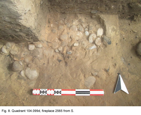
The latest of these (fireplace 2565) (Fig. 8) was recovered on floor 2564 (top. alt. 669.33). Its structure is similar to that of the fireplaces found in 2014 and 2015 in the overlying Late Bronze levels: in facts, it was surrounded by a low wall of compact yellowish clay, and was filled with superimposed layers of pebbles, pottery sherds, and clay burnt surfaces. Another, earlier fireplace (Locus 2570, top. alt. 669.29) was located in the south-eastern portion of the sounding; it consists of a simple cavity cut into the floor. At alt. 669.01, another reddish surface (2576), was cut by a fireplace (2571) and by two ash pits (2582 and 2583) (Fig. 9) that were probably used together with the latter.
The filling of the firing structure was composed of four different layers (from top to bottom): a reddish clay layer; an ashy layer, another layer of reddish clay, and a thin ashy layer, which covered its bottom. It appears that they represent at least two phases of use, as indicated by the presence of two superimposed red combustion surfaces.
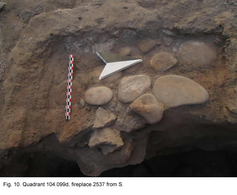
The main firing structure found this year (locus 2537) (Fig. 10) was recovered at alt. 668.85, at the very beginning of the transitional MB/LB sequence. It was delimited by a low clay wall, and showed a sequence of fillings of ash, clay plaster and pebbles. This fireplace was joined by another firing installation, which is visible only in the W section (locus 2594). Together with this, it composes a complex structure similar to those found in 2014-2015 in the LB levels (i.e. loci 2196, 2517, 2504) of the same quadrant, which consist of a main hearth surrounded by some smaller ones.
Below this level, a ca 130 cm thick MB occupational sequence (starting at alt. 668.68) was investigated. This consists of a series of filling layers which yielded Trialeti pottery. It did not contain any significant structures, exception made for a sort of a quadrangular clay installation, and a possible stone wall. At alt 667.91 (locus 2599) some sporadic fragments of Bedeni pottery started to appear. The last part of the sequence, which was exposed only on a small 100 x 80 cm wide area, contained exclusively Bedeni pottery. It is also interesting to observe that, while the sporadic Bedeni fragments recovered at the bottom of the MB sequence included both fine and coarse Bedeni wares, the last excavated layer, a thick dark-coloured filling (2908, top alt. 667.39) yielded a considerable amount of exclusively coarse ware. This suggests the presence of a stable Bedeni occupation of domestic character in this part of the site. Excavation stopped at alt. 666.93, at the bottom of this level.
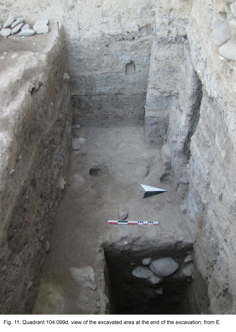
In spite of the small excavated area (which is due to the impossibility to remove the large Late Bronze stone wall) the sounding (Fig. 11) gave quite important results, both because of the unexpected thickness of the investigated Transitional and Middle Bronze levels, which are generally absent, or quite rarely present in the settlements of the Shida Kartli region, and because it definitely proved the existence of a Bedeni occupational level at the Aradetis Orgora Main Mound, which was one main aims of our excavations at the site.
It is also important to underline that this part of the site's occupational sequence was completely absent on the external, eastern side of stone wall 2202-2128, which had been excavated by us in 2013 in adjacent quadrant 105.099c. There, the massive stone wall appeared to have been founded directly on an ancient eroded slope of the mound (locus 2215), which sealed the latest layers of the Kura-Araxes period.
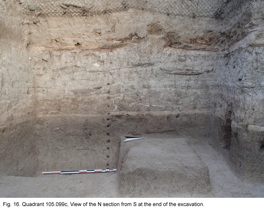
In quadrant 105.099c, we continued the investigation of the Kura-Araxes levels with the aim of reaching the level of virgin soil, which had been exposed in 2014 in adjacent quadrant 105.099d at alt. 664.40, and of thus obtaining a complete occupational sequence for this period. Excavation started at alt 665.60 ca, and was concluded after exposing the earliest human occupation surface (platform 2738 = 2314, alt. 664.67) over the whole surface of the quadrant, and excavating part of the underlying natural soil (alt. 664.42) on a limited area in the SW corner of the quadrant. Four main phases of occupation have been recovered.
The latest phase yielded no built structures, and is therefore to be interpreted as the filling of an open area. This is characterised by the presence of numerous small pits filled by different layers of ashes (which we interpreted as small fireplaces), burnt spots, and some flimsy installations. These features seem to be related to a sort of irregular platform (2760/2) located on the S side of square.
The second phase is characterised by a yellow compact surface (2735) cut by several post-holes (2736), which occupies the whole excavated area. The recovered post-holes are 23, but they probably belonged to different, not strictly contemporary structures, and we were not able to reconstruct any coherent building plan from them. Strangely enough, 10 of them appear to form couples of two small holes of 4 cm of diameter, dug at a distance of about 10 cm from each other. There seem to be no clear connection between these couple of poles, three of which are located on the northwestern side of the quadrant, while the remaining two are located on its northeastern side. The remaining post-holes have more or less the same dimensions (their diameter is about 6-7 cm) and just one (with a diameter of 14 cm) is definitely larger.
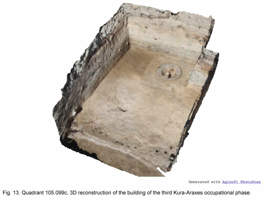
Surface 2735 was underlain by a thick layer of collapsed compacted material, which covered the remains of a space (hut 2732) of circular shape, only ¼ of which was included within the limits of the excavated quadrant (Figs 12, 13). The hut had a diameter of about 5 m; its E limit was marked by an alignment of 15 post-holes (locus 2731). It had a thick compact yellow floor (2729), which slightly raised in front of, and appears to stop just to the west of the post-holes, that had been probably dug into an underlying platform (2730 = 2312). No traces of the hut's wall were detected, except in the S section, where one of the post-holes appeared to be surrounded by a yellowish mass of clay; most probably the building had been levelled down to the level of its floor. Floor 2729, as visible in section, has been repeatedly re-plastered: it was composed of several thin superimposed layers of clay, for a total depth of about 5 cm. A complete in situ pentalobate fireplace (2727) was recovered in the centre of hut 2732 (Fig. 14).
North of the fireplace there was a large post-hole, whose function was probably to support the room's roof. The entrance was possibly (for comparison with other KA huts) placed to the S, in front of the fireplace. Fireplace 2727 was removed with the assistance of two professional restorers of the GNM (Fig. 15), and transferred to the local museum in Kareli.
Floor 2729 had been built directly on an about 20 cm thick platform (locus 2730), which had already been partially excavated in 2014 in quadrant 105.099d to the E (locus 2312). Together with hut 2732, platform 2730 = 2312 represents the third KA occupation phase excavated this year, which yielded the most important finds of the season.
The fourth (and earliest) phase of occupation is represented by another platform (2738 = 2314) cut by several post-holes (2746, 2747 and 2748) and by two shallow pits (2742 and 2744). Five of these post holes (locus 2748), located on the western side of square, appear to follow a curved line, and might therefore have belonged to a rounded structure, while the remaining ones had no intelligible orientation. Faint traces of a remaking of platform 2738 = 2314 are represented by an irregular line of whitish plaster half-way between this and platform 2730 = 2312, which was detected over part of the quadrant. No remains of any structure, post-holes or other installations were however preserved at this level.
As already observed in 2014, platform 2738 = 2314 was underlain by the natural soil (Fig. 16); it is therefore confirmed that the first occupation at least of this part of the site dates back to not earlier than the KA II phase, at the end of the fourth millennium BC.