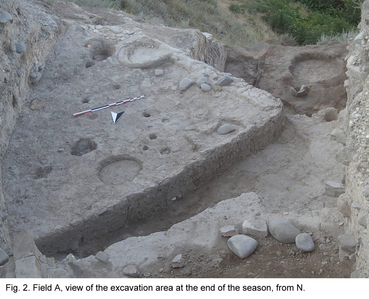
Field A, located on the south-western slope of the mound, has been the object of excavation since 2013. The northern step of the sounding (northern part of quadrant 097.100d), where excavation in 2015 had reached the levels of the late Late Bronze period, was abandoned in 2016. Excavation continued, in the southern part of quadrant 097.100d and in quadrants 097.099b and d, on two different steps (Fig. 2).
The upper step extended over the S part of quadrant 097.100d and over most of 097.099d. In this area, first of all we completed the investigation of the earlier stage of the Level 10 occupation (dated to the earlier phase of the Late Bronze Age), which had partially been exposed at the end of the 2015 season. At this time, the excavated area was divided into three different spaces dedicated to different functions: platform 1784 (a large platform of compacted clay of triangular shape oriented in SW-NE direction, which occupied most of the excavated area and hosted a large number of firing installations and some small pits), space 1776 (an open area with no formal floor filled with successive layers of dark-grey brown muddy soil, where most probably the remains of butchering activities were disposed of), and 1783 (an open area located in close proximity to the ancient mound's slope occupied by shallow pits frequently cutting each other).
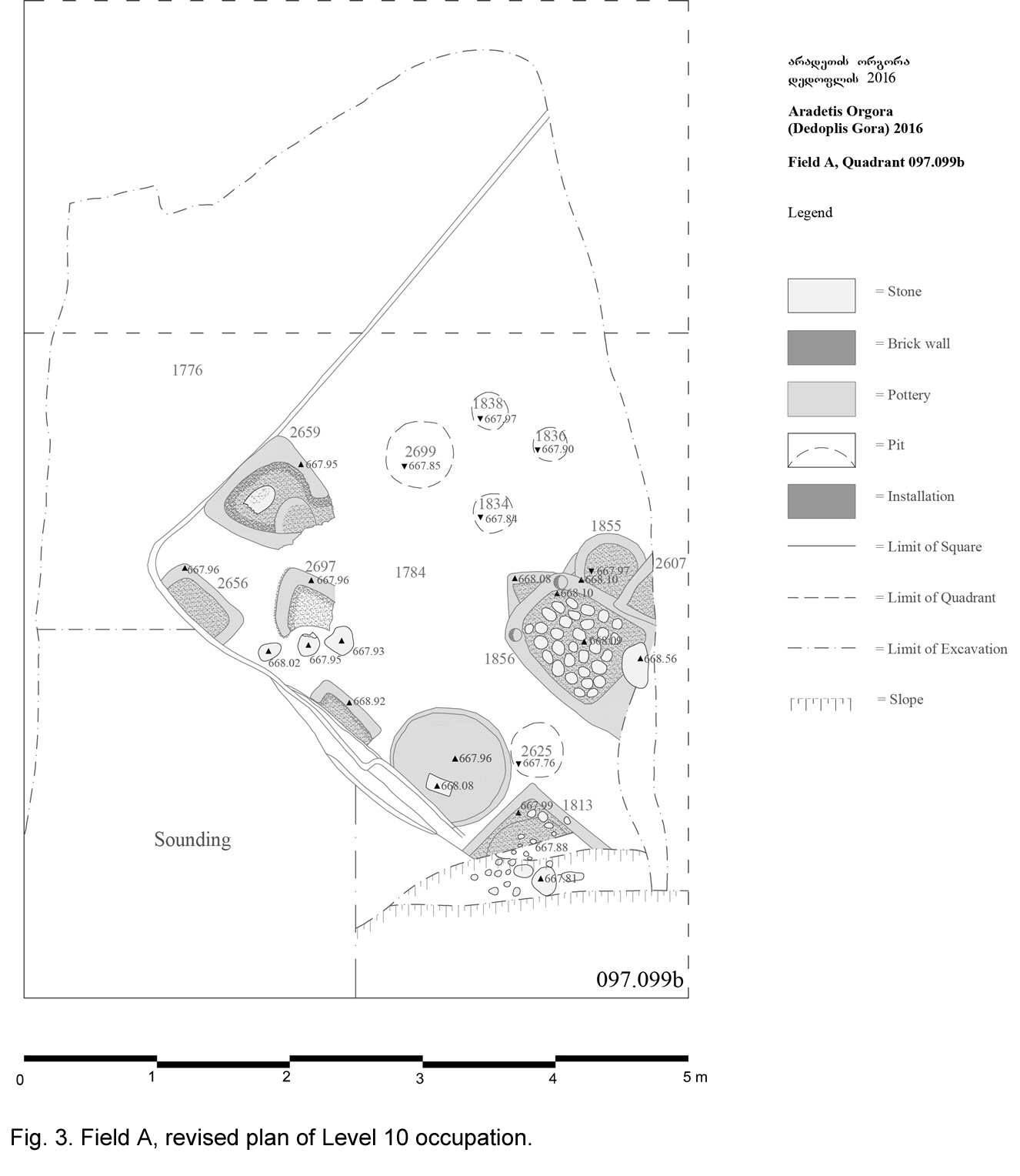
In the area of platform 1784, we completed the excavation of the platform's filling until reaching its bottom, at alt. 667.90 a.s.l. ca, where the remains of a previous occupation layer (Level 11) started to emerge. In the course of this operation, we discovered some additional installations which allowed to complete the plan of the platform and to better understand its function (Fig. 3).
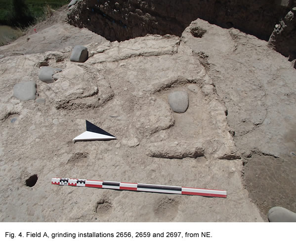
Installation 2607 (top alt. 668.15) along the eastern limit of excavation, for instance, was a small fireplace which belonged to a cluster of different firing installations (1855, 1483, 1856), similar to those excavated in 2015 in quadrant 104.099d in Field B. Most interesting was, however, the discovery, in the western corner of the platform, adjacent to its white-plastered limit, of a group of three installations (2656, 2659 and 2697) (Fig. 4) which appear to have had a different function from those excavated so far. In fact, they did not show any trace of fire and rather seem to have been low cavities and/or benches devoted to cereal grinding activities, as proved by the discovery, on one of them, of an in situ grinding stone. Platform 1784 is thus confirmed as an open-air place devoted to food preparation on a scale exceeding that of an individual household.
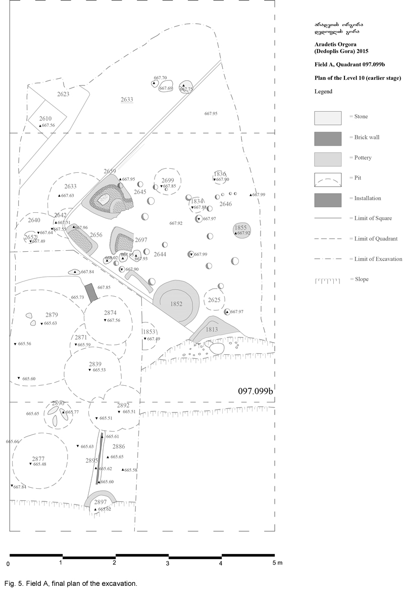
Excavation of the base of the platform revealed the presence of a number of post-holes (25 in total). These belong to an occupational phase (Level 11), which is earlier than the platform, during which the excavated area clearly had a rather different layout (Fig. 5). We tentatively distinguished three different alignments (2644, 2645, and 2646) probably belonging to round-shaped structures (huts) which seem to have extended beyond the limits of the platform, and to have been levelled and cut at the time when the platform was built.
In space 1776, we completed the excavation of the earliest fillings of this open area (loci 1863, 2611, 2631, 2632), until reaching, at alt. 667.73 ca, a surface of hard clay (locus 2636) which represents the bottom of the space. These fillings were similar to the fillings excavated last year in the same area, which overlay them: they consisted of dark-grey brown muddy soil with small sparse charcoals, and contained a huge number of large animal bones and pottery sherds.
At the north-western limit of the excavation, we discovered what may have been the limit of a second platform (2623) oriented parallel to 1784 at a distance of ca 1 m from it, on whose top a small square-shaped installation surrounded by ashes and charcoals (locus 2610) was detected.
The lower step of the excavation represents an extension of the deep sounding opened during the last week of 2015 at the southwestern corner of the excavated area. It extends over a 500 x 250 cm large area between the SW part of 097.099b and the NW part of 097.099d. The aims of the excavations were to better understand the nature of the Middle Bronze Age occupation discovered in the 2015 sounding, and to proceed to investigate the Early Bronze levels underlying it. Excavation started at alt. 667.90 a.s.l., at the level of the outer surface corresponding to the Level 10 platform, and reached alt. 665.60 ca.
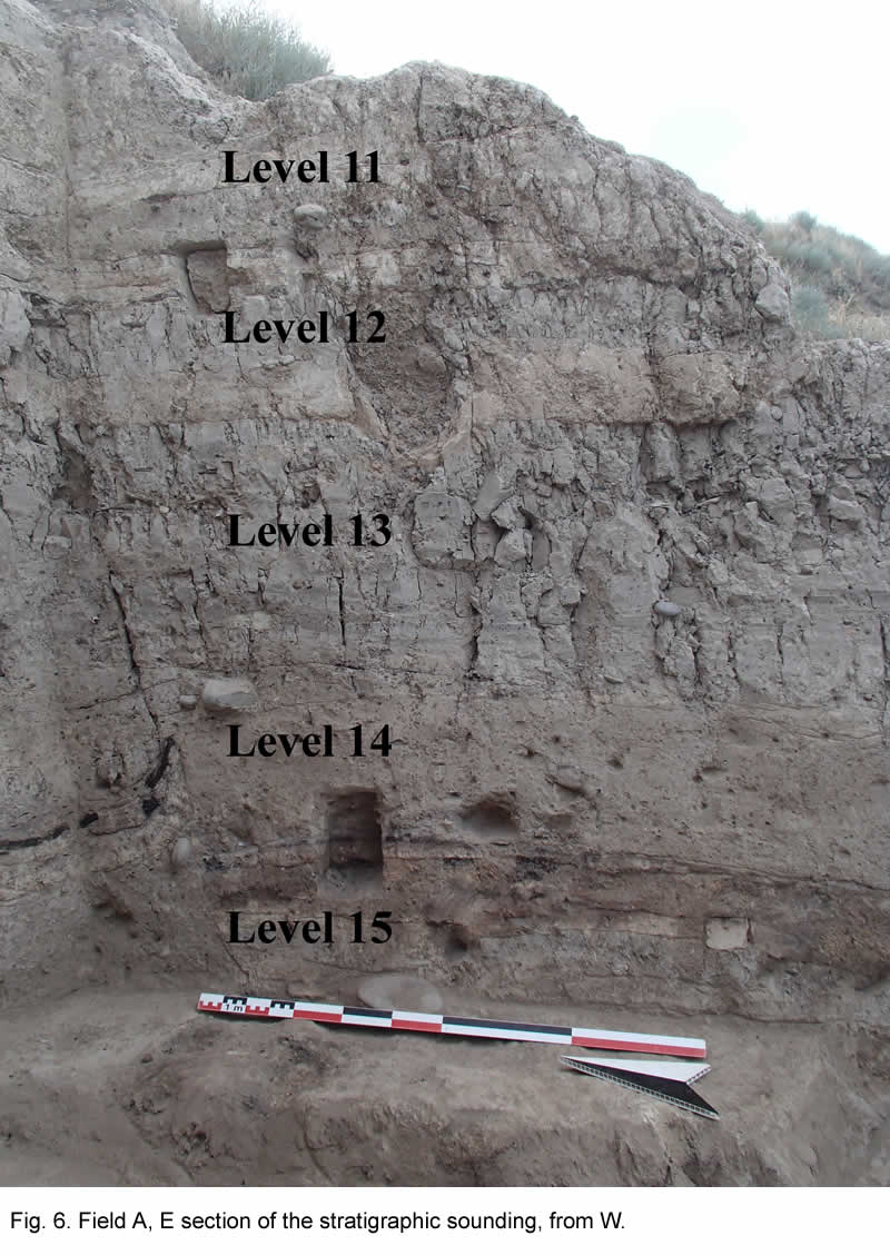
The recovered stratigraphical sequence was preliminarily divided into six main levels: Level 11 (ca 50 cm thick, with different sub-phases), which dates to the early Late Bronze Age, Level 12 (ca 20 cm thick), which yielded transitional LB/MB ceramic material, Levels 13-15 (up to 120 cm thick in total), which date to the Middle Bronze Age, and Level 16, at the top of which excavation stopped, whose exact date is still uncertain, which may represent the transition between the Middle and the Early Bronze Age (Fig. 6).
Level 11 occupation yielded a series of superimposed clay floors/surfaces on which different alignments of post-holes, joined, in one case at least, by flimsy remains of wattle-and-daub walls, were observed at different levels. As mentioned above, the latest of these surfaces is the one on which platform 1784 was built at a later stage (see Fig. 5).
Both Levels 12 and 13 were characterised by very thick accumulations of dark grey-brown mud (layers 2662, 2670) devoid of any built feature, which contained huge amounts of animal bones, joined by pottery sherds, obsidian and flint fragments. Layer 2662, which yielded Transitional LB/MB pottery, was separated by 2670, which can be ceramically dated to the Middle Bronze Age, by a thick layer of compacted clay, the surface of which was covered by a thin burnt layer. Level 14 under them was also characterised by a muddy filling (2676), which was however less rich in animal bones than the overlying ones, and was cut by several large pits cutting each other. The most significant structure of this level was a large cut-in feature of rectangular shape with rounded corners (locus 2803), the corner of which was underlined by the presence of two post-holes.
The following level (Level 15), also dated to the Middle Bronze Age, was characterised by a succession of fillings of fine light greyish soil (2829, 2835, 2862) on which, at different levels, alignment of post-holes, remains of thin wattle-and-daub walls and very damaged installations, and a number of cut-in features of different kind were observed. The latter belonged to two main types: shallow cavities (2857, 2865, 2830) filled with layers of burnt debris alternating with burnt surfaces, probably to be interpreted as temporary firing installations, and large very shallow rounded features with a diameter up to 200 cm (loci 2879, 2883) filled with a thin layer of fine compacted soil. The meaning of the latter is unclear; one possibility is that they represent the base of small temporary constructions. In spite of the small size of the excavated area, it is clear that the nature of the occupation of the Transitional MB/LB and especially of the MB periods is quite different from that of the overlying layers of the LB period which had been exposed during the previous excavation seasons: while the latter phase is characterised by the presence of some recognisable architectural features and by a considerable functional continuity in the use of the space, the former appears to represent different episodes of rather ephemeral occupation, possibly by groups practicing a mobile style of life. Construction techniques also appear to have considerably differed between the two periods, with wattle-and-daub technique being apparently almost exclusive during both the Transitional MB/LB and the MB periods, and absent in the LBA. Although this well agrees with the traditional interpretation of MBA groups as mobile pastoralists, it should be noticed that the very thickness of the Middle Bronze layers (ca 1.20 m) suggest a more than sporadic frequentation by them of the Aradetis Orgora settlement, which due to its strategic importance was probably one of the few centres of the region to remain occupied throughout this period of reduced settlement intensity.
Pottery sherds of Early Bronze date (Kura-Araxes and, to a lesser extent, Bedeni period) started to appear with increasing frequency in Level 15, in association with MBA pottery. This may either be explained by the large quantity of MB pits cutting into the earlier levels or, alternatively, it may indicate a short period of abandonment of the area.
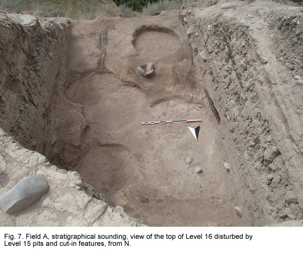
Excavation was interrupted at the bottom of Level 15 (at alt. 665.60 ca), when we met an extended burnt layer (2886) from which the remains of a wattle-and-daub wall (2895) oriented in north-south direction and of some possible installations emerged (Fig 7). This represents the top of the next level (Layer 16) which appears to be characterised by more substantial architecture, which may represent the latest EBA occupation in this part of the site.