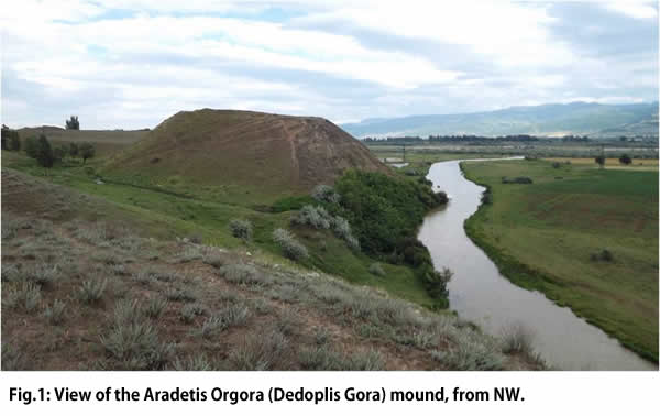
Aradetis Orgora is a large site located in the district of Kareli, on the left bank of the Western Prone River, near the confluence of the latter with the Kura. The main mound (also known as Dedoplis Gora) (Fig. 1) has a roughly triangular shape with quite steep sides, and is approximately 70-80 m long and 34 m high on the present level of the river.
It had been repeatedly investigated, since 1926, by different Georgian teams. Regular excavations have been carried out at the site, since 1985, by prof. Iulon Gagoshidze of the Georgian National Museum (see Gagoshidze et al., Iberia and Rome, Langenweißbach 2008). They have revealed the ruins of an important palace of the Late Hellenistic-Early Imperial age, which occupied the present top of the mound. According to the previous excavators, the archaeological levels at the site amounted to a maximum thickness of 14 m, and included remains of the (Chalcolithic), Early Bronze, Late Bronze, Early Iron, Hellenistic, Roman Imperial and Early Medieval periods. River erosion on the SW side of the mound produced an exposed section, which revealed an imposing sequence of layers spanning from the 4th to the 1st millennium BC.
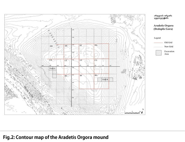
The main aim of the 2013 excavation at the site was to verify the settlement's occupational sequence, the extension of its pre-classical occupation and the state of preservation of the earlier (especially of the 3rd and 4th millennium BC) levels and, at the same time, to obtain a corpus of stratigraphically secure artefacts and ecofacts from the different occupational phases of the site. In order to accomplish these aims, two different soundings were opened at the opposite sides of the mound (Fig. 2).
The first one (Field A) was located on the South-Western slope of the mound, at a point where this was especially steep, and where in situ Early Bronze material (notably Kura-Araxes and Bedeni pottery) were noticed on the exposed section on the occasion of a visit to the site by the expedition team in 2009. It consisted of a 5 x 5 m quadrant (097.100d) which was progressively enlarged in S direction, as excavation proceeded, to part of a second 5 x 5 quadrant (097.099b). The excavation of three additional quadrants (097.100a, b, and c) had been planned, but had to be abandoned soon after its beginning because of the presence of substantial remains of the Late Hellenistic/Early Imperial palace, which could not be removed. The second sounding (Field B) was situated on the Eastern mound's slope, and consisted of a sequence of four 5 x 5 m squares (103.099d, 104.099b, d and 105.099b), oriented in East-West direction, in the area outside of the Hellenistic period palace. On this slope, surface material was very scanty, so the first aim of the investigation was to verify the presence and extension of the pre-Hellenistic occupation.
FIELD A
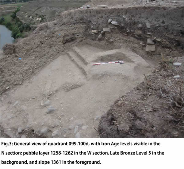
The depth of archaeological layers investigated in Field A amounted to more than 3.00 m, from 672.50 m a.s.l. - this corresponded to the bottom of the Late Hellenistic palace investigated by the Georgian expedition, of which the base of one of the courtyard's pillars was cleaned in quadrant 097.100b - to 669.20 a.s.l. A total of 6 main occupational layers were investigated, spanning from the Hellenistic to the Late Bronze period.
During the Iron Age, the investigated portion of the mound was occupied by a thick sequence of horizontal surfaces belonging to open spaces paved with grit or small pebbles or plastered with mud, sealed by thicker pebbles layers, with only scanty remains of stone or mud-brick walls and installations (see Fig. 3, N section). A considerable number of pits, most of them for cereal storing judging from the large amounts of charred seeds which were recovered inside them, concentrated in the Southern part of the excavated area, near the present eroded slope.
The transition between the Late Bronze and the Iron Age period is marked by a significant discontinuity in the occupational sequence of this part of the mound, which corresponds to an eroded sloping surface covered by an up to 1 m thick layer of small pebbles (locus 1258, 1262, Fig. 3). Future analysis of the stratified pottery from the area, coupled with a sequence of 14C dates from the same levels, will offer the possibility to obtain a reliable ceramic sequence for the Shida Kartli region in the late 2nd and 1st millennium BC, to be compared, e.g., with that of the neighbouring settlement of Khovle Gora, for a better defining of the Late Bronze/Early Iron Age transition in the area.
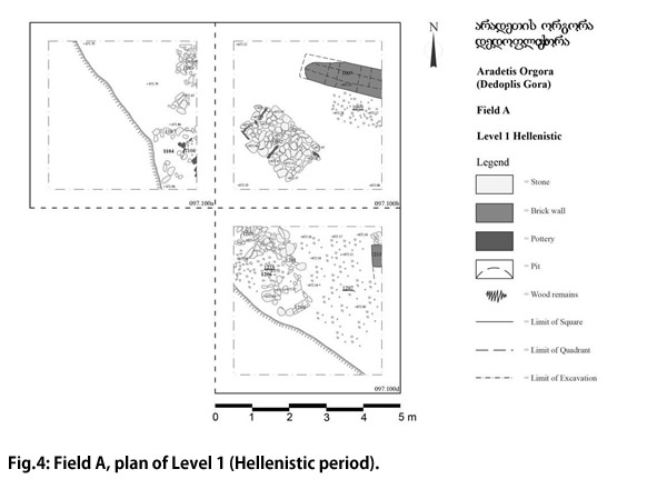
The latest level (Level 1) dates to the Hellenistic period, previous to the construction of the Palace excavated by the Georgian mission. It was partially exposed over three 5 x 5 quadrants (Fig. 4) and consisted of an open area paved with small pebbles and grit, with partially preserved rooms oriented in NE-SW direction delimited by stone walls (loci 1104, 1206) and scanty remains of mud-brick walls.
The following levels (2 to 4) have been attributed to the Iron Age, preliminary attributions to different phases of the latter being only tentative at this stage of the analysis. They have been excavated over a 5 x 5 m surface, corresponding to quadrant 097.100d.
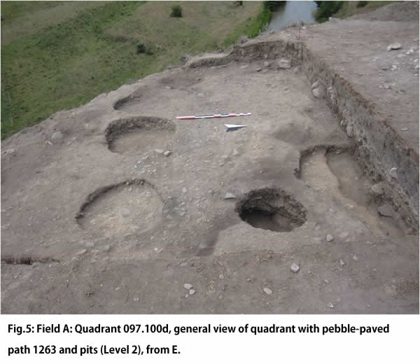
Level 2 (Fig. 5) has been provisionally dated to the Achaemenid/Early Hellenistic period. During this phase, the excavated area was crossed by a grit ad pebbles-paved path (locus 1263) running in NW-SE direction, on both sides of which there were a number of grain-filled pits. The bottom of the level was marked by a thick layer of pebbles which covered the whole area. The layout of the area at the time of Level 3 was similar to that of Level 3: a central area, sparsely paved with sherds and pebbles and oriented NW-SE, was flanked on both sides by a large number of storage pits.
Another layer of pebbles separated Level 3 from Level 4. This was tentatively attributed to the earlier Iron Age (10th-8th centuries BC ?) and showed at least two different phases. During the later one, the North-Eastern E portion of the quadrant was occupied by a clay floor covered by a thin layer of burnt soil. Two different firing installations were lying on this floor: the first one (locus 1299) consisted of a small mud-brick ring, while the second one, which reused some stone walls belonging to the earlier phase, was used as a kiln, to judge from the large amount of slags which were recovered in its filling. The South-Eastern part of the quadrant was occupied by a large number of pits cutting each other; an irregular alignment of stones appear to have divided the two areas.
During the earlier sub-phase, divided by another pebble layer from the later one, the area had a similar layout; the North-Eastern portion of the quadrant was occupied by the corner of a room with stone walls (1305), which was later re-used as a firing installation. Some ephemeral mud-brick walls appear to have been connected with this room; the North-Western part of the quadrant was occupied by a simple clay surface, and its whole southern part, similar to the later phases, by a large number of pits.
Level 4 was the earliest level attributed to the Iron Age. As we anticipated, it was underlain by an extremely thick layer of pebbles (locus 1358-1362), which marked a complete discontinuity in the area's occupational sequence and was not even disturbed by any later pit. The top of the pebble layer was horizontal, while its bottom was heavily sloping both toward the South and the East, and covered what we interpret as an old surface of the mound (1361) which, to judge from the smooth appearance of its top, must have remained exposed for a considerable lapse of time.
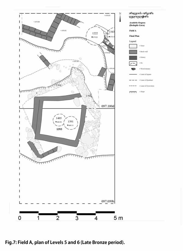
Surface 1361 sealed a sequence of successive levels belonging to the Late Bronze Age. Two of these were exposed on a limited surface on the top (Level 5) and, respectively, on the bottom (Level 6, Fig. 6) of the slope. It is to be expected that additional LB layers will be discovered between Levels 5 and 6, after the former will be excavated next year (Fig. 7).
Level 5 yielded four mud-brick walls oriented in slightly NW-SE direction. Level 6 had two different sub-phases: the upper one yielded a complete room of squared shape with mud-brick walls (space 1393), measuring ca 2.00 x 2.00 m, while the second one was characterised by substantial stone walls originally covered with mud-bricks (1388, 1402, 1401, 1406), the continuation of which is still covered by surface 1361. Excavation in Field A stopped at alt. 699.20 a.s.l. To judge from preliminary observations of the exposed section of the Prone River, virgin soil in the area would lie about four meter deeper, the earliest levels which have been hitherto recognised belonging to the Kura-Araxes period. The task for the next excavation campaign, which is foreseen for June/July 2014, will be to excavate the rest of the Late Bronze and the Early Bronze (Bedeni and Kura Araxes) levels, and to verify the possible presence of still earlier occupational layers.
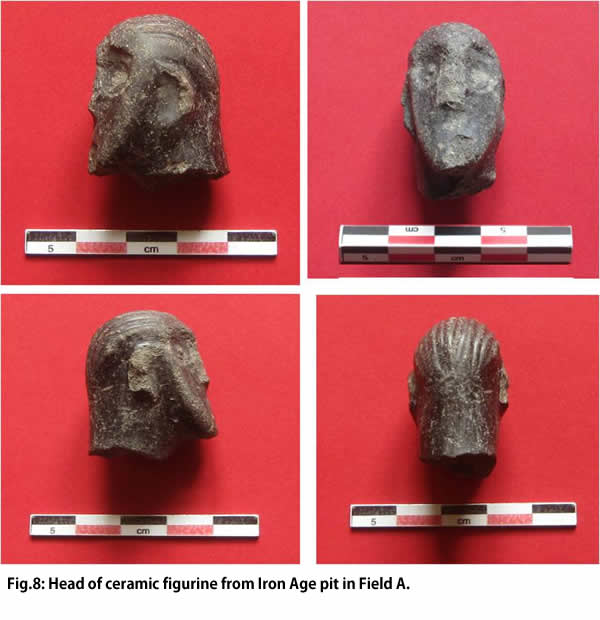
Among the most significant finds from Field A, especially interesting is the head of a small terracotta figurine of very fine manufacture (1366-M-1, Fig. 8) coming from an Iron Age pit.
FIELD B
Since the slope on the Eastern side of the mound was less steep than on the Western side, a different excavation strategy, namely that of a "step trench" was adopted in order to reach the earlier levels. The top of the excavation area lay at alt. 676.65, its bottom at alt.: 665.65, corresponding to a total depth of excavated layers of 11 m (Fig. 9).
Excavation of the first "step" (quadrant103.099d) was stopped after exposing the top of the remains (burnt brick collapse and top of collapsed stone walls) of the Late Hellenistic/Early Imperial palace, which will be excavated by the Georgian team in the future.
The collapsed walls of this building extended also in the Western part of the next quadrant (104.099b), which was abandoned for the same reason. Under the Hellenistic/Early Imperial layer, in the Eastern part of the quadrant, a succession of late (?) Iron Age external surfaces (2012, 2015, 2019), interspersed with pebble layers was brought to light. These were underlain by an up to 1.95 m high sequence of pebble layers (locus 2036), underlain by a layer of reddish clay (locus 2038), at the level of which excavation stopped.
In the following quadrants, the whole surface of the mound under the humus layer was covered by a layer of small pebbles, at least partially deposited by slopewash activity, the origin of which is most probably connected to layer 2036 described above. Under these, in quadrant 104.099d a sequence of horizontal surfaces with scanty architectural remains (mud-brick and stone walls), separated by pebble layers was brought to light, which according to the recovered pottery date back to the earlier (?) Iron Age (see Fig. 10). The earliest of these layers appears to have been cut, possibly in connection with the construction of the large stone wall (2202) located in the next quadrant 105.099c, the filling of which continues in the Eastern half of 104.099d.
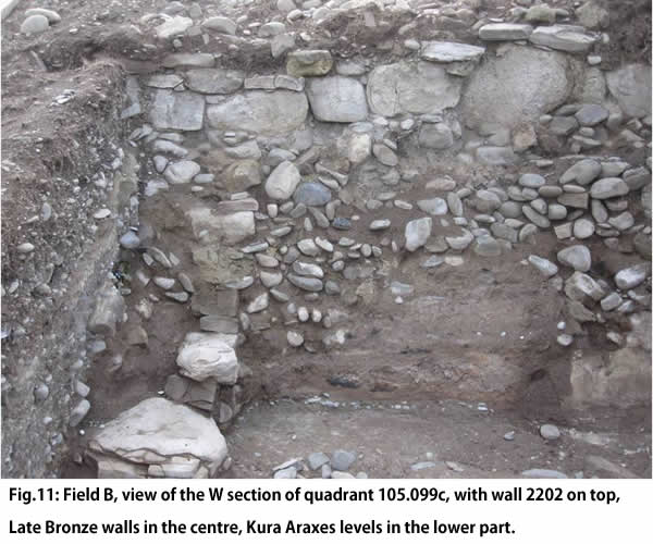
The most interesting results came from the last quadrant of the sequence, 105.099c. (Fig. 11). Here, a huge stone wall (2202, bottom alt.: 668.27) running in NS direction, which we tentatively attribute to the Early Iron Age, was unearthed just under the subsurface soil. The Eastern face of the wall was made of squared blocks of sandstone, ca 50 cm wide and more than 20 cm high, and its filling consisted of large pebbles, which continue into adjacent quadrant 104.099d. Wall 2202 overlay the partially collapsed remains of stone constructions (walls 2210, 2211 etc.), up to 1.20 m high, which according to the pottery recovered in them can be attributed to the Late Bronze Age. These has been built on an ancient slope of the mound (locus 2215), which to judge from its smooth appearance had been exposed for a certain amount of time, and had partially collapsed over the latter. The foundations of the Late Bronze structures, which continue in the unexcavated area covered by wall 2002 and could therefore not be completely excavated, deeply cut into the levels sealed by surface 2215.
These consisted of a sequence of thin compacted occupational layers dated to the Kura Araxes period (early 3rd millennium BC). In the first of these, only scanty remains of collapsed mud-bricks and/or wattle-and daub structures could be identified, while the second one yielded two small rooms delimited by thin mud-brick walls. These were lying on a thick white-plastered surface (locus 2236), which was in its turn underlain by a floor of small pebbles (locus 2238). The last layer excavated in this area yielded two thick pisé walls (2242, 2243), which formed a right corner; the space between them was filled with grey ashes.
Finally, is it to be mentioned that a few out of context Bedeni sherds were also found in this quadrant, mostly among the collapse of the Late Bronze structures.
CONCLUSIONS
In conclusion, the 2013 investigations at Aradetis Orgora proved beyond doubt the existence of well preserved 4th-3rd millennium BC levels, overlain by a sequence of levels of the 2nd and early 1st millennium BC, at least over the whole South-Western and Eastern sides of the present mound, and thus confirmed the supposed importance of the site as a regional centre since at least the end of the Late Chalcolithic period. It is also to be underlined that the site has provided evidence for still earlier human frequentation, as shown by two stone tools, possibly dating back to the Palaeolithic period, one of which has been reused in a pebbles floor of the Kura-Araxes period in Field B, and the second one (Fig. 12) was casually discovered in the E slope of the mound.
This rare situation offers very promising opportunities for future investigations at the site, which undoubtedly has the potential to become a key-site for the archaeological periodisation of the Shida Kartli region, the only difficulty being the thickness of the later levels which should be removed in order to investigate the earlier ones on a wider surface.
Our aims for the next (2014) season are therefore:
1) to continue excavation in Field A until reaching the virgin soil.
2) to expand the excavation area in Field B by a) opening a new quadrants (105.099d) in E direction, in order to reach the virgin soil in this area, and b) opening two new quadrants N and/or S of 105.099d, in order to increase the exposed surface of the early 3rd millennium layers excavated there.
3) To deepen excavation in the upper quadrants of Field B, with the aim of reaching the Early Bronze layers there.
4) Finally, we do not exclude to investigate a small area between the Aradetis Orgora settlement and the new highway trench, to the N of the former, with the aim of excavating some Kura-Araxes graves.