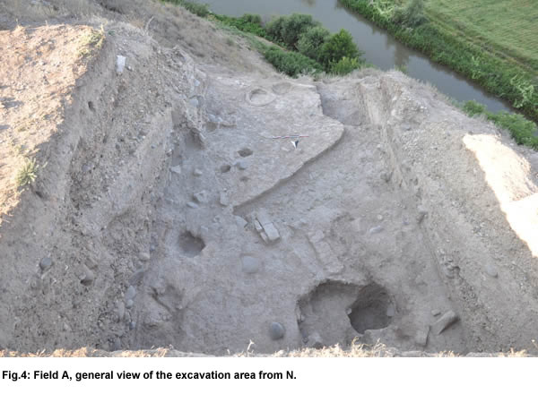
In Field A, situated on the South-Western slope of the mound, excavation continued in both quadrants (097.100d, 097.099b) already excavated in 2013 and 2014 but expanded, toward the end of the season, to a small portion of quadrant 097.099d to the S, on the outer edge of the mound's slope (Fig. 4). Excavation was carried out in parallel on two steps, namely at the top (in the N half of quadrant 097.100d) and at the bottom (in the S half of quadrant 097.100d and in quadrant 097.099b) of the ancient slope of the mound exposed in 2013, with the aim of investigating the earlier Late Bronze sequence of occupation of the area. The total depth of the excavated layers amounted to ca 60 cm on both steps; the last exposed level can be tentatively attributed to the 14th century BC on the basis of ceramic parallels. In the course of the last week of excavation, a 150 cm deep sounding was carried out on a 150 x 350 cm large area located at the SW limit of the Field. This reached alt. 666.35 a.s.l., thus bringing the total depth of archaeological layers excavated in the area in the course of three years to more than 6.15 m (from 672.50 m a.s.l., corresponding to the bottom of the Late Hellenistic/Early Imperial palace, to 666.35).
In quadrant 097.100d, we completely removed what was left of the very thick pebbles filling (loci 1531-1554-1567) partially excavated at the end of the 2014 season. This covered a layer characterised by the presence of massive stone walls (1571, 1572, 1573, 1574) oriented in different directions, which had been levelled almost down to their bottom. A large post-hole surrounded by a circle of stones (1569) was discovered at the junction between walls 1571 and 1572. No floor was found leaning to these walls, so that it is possible that they had a mere terracing function; on the other hand, the absence of the floor may be due to the bad state of preservation of the level. The relation of walls 1571, 1572, 1573, 1574 with the stone walls (1400, 1401) discovered in 2013 at the S limit of the excavation area just under the ancient mound's slope is not certain: it appears that the latter cut the former and are therefore later, although both belong to the same main phase of occupation.
Walls 1571, 1572, 1573, 1574 lay on a hard surface of trampled clay (1568) which covered the following level. This was heavily disturbed by the presence of some large pits; only after emptying them, during the last days of excavation, some traces of structures (a mud-brick wall, 1905, a possible firing installation, 1589, fragments of possible floors and wall plaster) were starting to emerge. Ceramic material from this earliest level apparently dated to the earlier Late Bronze period (13th-14th century BC ?), although a precise synchronisation with the sequence of the adjacent quadrant 097.099b is not yet possible.
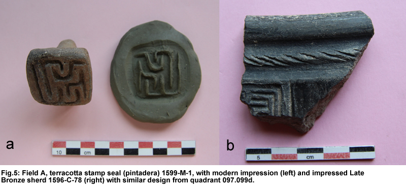
A welcome find from the last day of excavation in the area was a terracotta stamp seal or pintadera (Fig. 5, left) decorated with a geometric pattern possibly representing a stylised long-horned quadruped standing to the left. Similar objects are attested during the Late Bronze Age over the whole territory of Georgia; since no clay impressions of them are known, they are generally interpreted as pintaderas rather than as stamp seals. In this respect, it is interesting to observe that very similar designs, although generally of smaller dimensions, were also impressed on contemporary pottery vessels (Fig. 5, right).
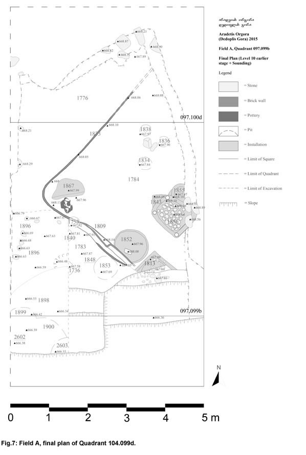
On the lower step of the excavation, in the S part of quadrant 097.099b and over the whole area of quadrant 097.099b, we continued the investigation of level 10 (earlier phase of the Late Bronze Age) whose top had been exposed during the last days of the 2014 season. Level 10 was ca 60 cm thick, and could be divided into two main sub-phases, each one with further internal subdivision (Figs. 6, 7). The function and general layout of the excavated area remained the same throughout the whole period, and were not much different from those of Level 9 excavated in 2014, which suggests a significant continuity of occupation of this portion of the settlement throughout the Late Bronze Age.
The excavated area was divided into three different spaces dedicated to different functions. Space 1776, in its NW part, was a open area with no formal floor filled with successive layers (1740, 1844, 1863) of dark-grey brown muddy soil with small sparse charcoals containing a huge number of large animal bones and pottery sherds. According to the expedition's palaeozoologist, the space may have contained the remains of butchering activities. Space 1783, in the SW part of the excavated area, was an open area located in close proximity to the ancient mound's slope, and was occupied by shallow pits, frequently cutting each other but apparently disposed in different layers separated by thin layers of compacted soil.
The area between spaces 1776 and 1783 was occupied by a large platform of compacted clay oriented in SW-NE direction (locus 1784), which extended over the whole eastern half of quadrant 097.099b, and continued in E direction beyond the limit of excavation. During the later sub-phase, platform 1748 was surrounded by two narrow channels (gutters 1727 and 1758), which abutted a small pit (1789) located near the W corner of the platform. During the earlier sub-phase, the outer limit of the platform was coated with a thick layer of white plaster, which had been repeatedly renewed.
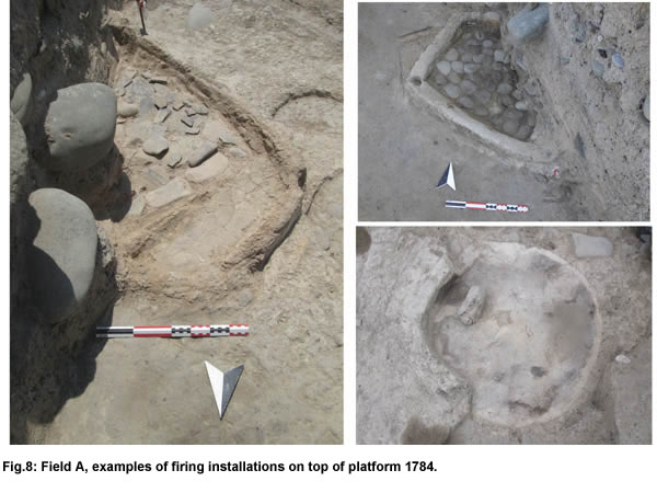
The top of platform 1748 had no formal floor, but traces of different surfaces of use could be distinguished on it; it was occupied by a large number of firing installations of different shapes (some were round-shaped, while others were quadrangular with rounded corners) (Fig. 8). These were often re-built in approximately the same position, occasionally cutting similar features belonging to a previous stage. The installations had generally been levelled to just a few cm above their bottom: most of them appeared to have been surrounded by a shallow clay wall, on top of which some post-holes were occasionally observed, although one or two of them may have been small covered ovens, to judge from the fragments of a possible collapsed roof which filled them. The firing area, consisting of a flat surface of burnt clay, was generally underlain by a layer of pottery sherds, which in its turn overlay a layer of small pebbles, a pattern which has been observed elsewhere in the Late Bronze period at the site (e.g., in quadrant 104.099d in Field B). Soil micromorphology analysis of these features is in progress in order to ascertain whether their morphological variety may be linked to different specific functions.
To the W of the W corner of platform 1784, spaces 1776 and 1783 were divided by an irregular assemblage of stones, which had a different shape and orientation in the two sub-phases of the layer (loci 1775, 1842), and may represent the remains of stone walls continuing in the unexcavated area to the W of quadrant 097.099b.
At alt 667.40 ca., the bottom of platform 1784 can be considered to represent the base of Level 10. The underlying layers were only excavated in the area of sounding 1886 in the SW corner of quadrant 097.099b, extending over a small part of adjacent quadrant 097.099d. The upper part of the sequence, which according to its ceramic finds can be dated to the transitional MB/LB period (15th century BC) consisted of a succession of surfaces of yellowish clay overlain by a thin layer of grey burnt soil (possible walking surfaces of an external space). Under these there was a ca 60 cm high succession of thick layers of dark grey-brown mud cut by few pits and by two possible firing installations, which contained a large quantity of animal bones and, interestingly enough, a huge amount of obsidian fragments, including both tiny flakes and rather large blocks, as had never been found in any of the overlying level. Ceramic material from this earlier part of the sequence was mixed: besides a small amount of Late Bronze sherds, possibly intrusive from the nearby eroded slope, it mainly contained MB material, including one Trialeti incised sherd, joined by occasional Early Bronze age sherds (a handful of Kura-Araxes sherds, and, notably, one possibly Bedeni sherd). Excavation stopped at the bottom of the sequence of muddy layers, where, at alt. 666.38, the remains of an earlier occupational phase (a yellowish surface, a floor covered by grey ashes) started to appear. No diagnostic material was recovered from these surfaces, but they may represent the interface between the MB and the EB occupation in this part of the settlement.
In spite of the small excavated surface, sounding 1886 clearly proved that the top of the Dedoplis Gora mound was not completely abandoned during the MB period, but was continuously occupied, although apparently with a less intensive pattern of occupation than during the following LB period. Besides elements of continuity with the latter phase (e.g. the presence of large amounts of discharged animal bones, which indicates that animal breeding played an important role in the economy of the ancient local population), new elements appear to characterise the MB occupation, the most significant of which being the large amount of obsidian flakes. This may suggest that the local population had a privileged access, during this period, to the sources of obsidian (presumably the Chikhiani volcano in the region of lake Paravani) located to the South, beyond the Southern Caucasus range.