Field A (Fig. 3) is situated on the South-Western slope of the mound, at a point where this is especially steep, and where in situ Early Bronze material (notably Kura-Araxes and Bedeni pottery) had been noticed on the exposed section on the occasion of a visit to the site by the expedition team in 2009. It consists of two 5 x 5 m quadrants oriented in NS direction (097.100d, 097.099b). This year's excavation started from the top of the Late Bronze levels, which had been exposed at the end of the 2013 season, and resulted in the investigation of ca 1 m of occupational LB deposits, thus bringing the total depth of archaeological layers excavated in the area to more than 4 m, from 672.50 m a.s.l. (corresponding to the bottom of the Late Hellenistic/Early Imperial palace) to ca 668.40 m a.s.l.
Excavation was carried out in parallel on two steps, namely at the top (in the N half of quadrant 097.100d) and at the bottom (in the S half of quadrant 097.100d and in quadrant 097.099b) of the ancient slope of the mound exposed in 2013.
In the former area, only a sequence of filling layers, heavily sloping in S direction, occasionally cut by pits and with rare, very poor remains of tiny collapsed walls, was found under the ancient slope of the mound. The walls discovered last year at the northern limit of the quadrant (Level 5) probably marked the limit of this empty area in northern direction. The above-mentioned sequence of fillings, which contained only Late Bronze material, was underlain by a very thick layer of pebbles (locus 1531-1554), the bottom of which, at alt. 669.70 a.s.l., approximately corresponded to the level of the massive stone walls of space 1399 ("Level 6"), which had emerged last year at the bottom of the slope. The outer face of two of these walls (1400, 1401) was reached and exposed at the end of the season in this part of the excavation. Strangely enough, a number of Kura-Araxes sherds of unknown origin was discovered in the filling leaning to these walls.
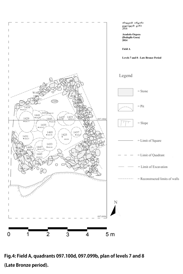
A quite different situation was met with in the lower portion of the sounding, at the bottom of the ancient slope, which was clearly terraced, since here we found a sequence of successive occupational layers dating to the Late Bronze period. First of all we clarified the relation between the stone walls of space 1399 (1388, 1400, 1401, 1402) and the mud-brick walls of room 1393 (1390, 1404, 1387 and 1407) exposed in 2013, which had then both been attributed to "Level 6". The latter actually represented a later addition (Level 6), possibly contemporary to the Level 5 walls on top of the slope, which had been dug inside space 1339, thus completely obliterating the floor and filling of the latter, which we presently attribute to Level 7. After completing the plan of the walls of space 1399 (Fig. 4), thereby discovering an additional stone wall (1421) running from this in S direction, we removed them. The next level (Level 8) was represented by a large number of pits, often cutting each other, to which only a badly preserved pisé wall (locus 1456) could be tentatively associated.
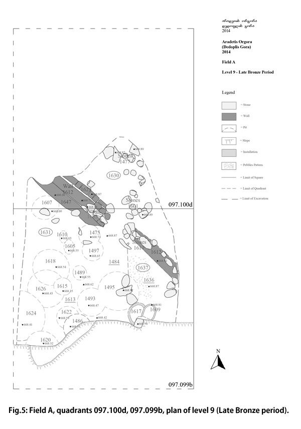
There followed a period (Level 9) in which the excavated area was divided into three different spaces dedicated to distinct functions, a general layout which, in spite of slight modifications in their limits in the course of time, was preserved over the different sub-phases (Fig. 5). Space 1630, which occupied the NE part of the area, was filled with successive layers (we could distinguish at least 5 of them, for a total depth of ca 60 cm) containing a huge number of animal bones and pottery sherds, some stone tools (mainly fragments of grinders, pestles etc) and a considerable amount of charcoals. The space had no formal floor, and was delimited, in the different sub-phases, by irregular alignments of stones cemented with clay ("wall" 1612), or simple raised bands of clay ("walls" 1659, 1670) running in NW-SE direction, with a possible opening approximately in its centre. It was most probably an open space in part of which butchering and other food processing activities were possibly carried out, and which was mainly used for disposal of the remains of such activities. A division into a NW and a SW area was marked by the constant presence of a stone assemblage/alignment just S of the supposed entrance.
Space 1637 occupied the SE part of the excavated area. Only a small part of it was preserved, since its southern continuation was damaged by slope erosion. It was also an open space, occupied by small, frequently renewed firing installations (fireplaces 1473 and 1482 in the latest sub-phases fireplaces 1609, 1617 in the earlier ones). Traces of successive surfaces paved with small pebbles (1484, 1636) were found in this area.
The rest of the excavated area (space 1631) was occupied by a surface (1613) which was clearly located on the outer edge of the ancient mound. It was heavily sloping in both S and W direction, and was constantly occupied by shallow pits, frequently cutting each other but apparently disposed in different layers separated by thin layers of compacted soil. Only in the earliest sub-phase, probably contemporary to the bottom of space 1630, a clay installation (1657) was found in the NW corner of this space. This consisted of a sort of clay platform with stepped outer limits delimited by a raised band of clay with remains of a thin white plaster on top, resting on a base of sparse stones, and flanked on the E side by a lens of ashes and charcoals.
During the very last day of excavation, there appeared a number of features which let us suppose that we have reached a stage (Level 10?) in which the area had a different layout. The whole excavated surface was again disturbed by different pits, apparently sealed by a greyish layer containing small charcoals, which extended also over the area later occupied by space 1630. In the area spared by these, we found a sort of ovoid platform of yellowish compacted clay (1719) and, to the S of this, a tiny mud-brick wall running in NW-SE direction, flanked by a narrow and shallow gutter.
The investigation of this level will be the first task for next year's campaign. The aim of the next season in Field A will be to complete the investigation of the LB accumulation, to reach the top of the Early Bronze (Bedeni and Kura-Araxes) levels, which should lie less than 1 m deeper, and proceed with their excavation. To judge from preliminary observations of the exposed section of the Prone River, virgin soil in the area may lie about 3 m deeper.
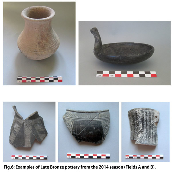
The 2014 excavation in Field A yielded a rich repertory of stratified LB pottery, much of it with incised and plastic decorations (zoomorphic handles, etc.), dating to the early (14th-13th cent.) as well as to the later (12th-11th cent.) phases of the period. Together with the contemporary pottery excavated this year in Field B (see infra) and with the pottery of the Transitional Late Bronze-Early Iron period and of the later EI excavated in both fields in 2013, this material (Fig. 6), which is in course of study in the framework of a PhD dissertation at Ca' Foscari University of Venice, will offer the possibility to obtain a reliable 14C-supported ceramic sequence for the Shida Kartli region in the later 2nd and 1st millennium BC, to be compared, e.g., with that of the neighbouring settlement of Khovle Gora.
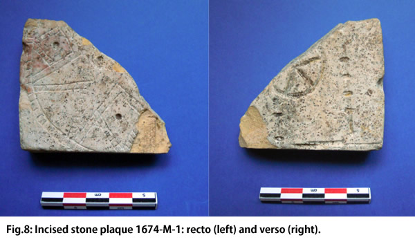
The two most important small finds of the season come from this part of the excavation, more precisely from the succession of fillings of open area 1631. The first is a bead of gold foil (1479-M-4) with bitumen (?) traces on the back ( Fig. 7). Gold finds are quite rarely found in LB levels in Georgia. The bead belongs to a type which is very common in the 3rd mill. BC, and might therefore had been re-used, although some similar items (in bronze) have been found in LB graves in the neighbouring Doghlauri cemetery (I. Gagoshidze, personal communication). The second one is a fragment of a small stone plaque (1674-M-1) decorated on both sides with incisions (Fig. 8). One of the sides shows a finely incised ten-pointed star: this is strongly reminiscent of the Mesopotamian symbols of the sun-gods Shamash and/or of the goddess Ishtar (the Venus planet), which frequently occur since the Old Babylonian period in both Mesopotamia and Syria (see, among others, the famous golden pendants from Dilbat, Ebla, etc.), but are hitherto unattested, as far as we know, in contemporary levels in the Southern Caucasus. The back side of the plaque shows a number of more coarsely incised designs, maybe resulting from secondary working: it may have been used in the production of small jewels in metal foil. The discovery of these two remarkable objects confirms the importance of the site during the second half of the 2nd millennium BC and highlights the existence of wide-ranging connections of the Shida Kartli region in this historical phase.