back
The main activity of the season was the excavation of two kurgans at the site of Okherakhevi between the Nichbisi and Kvemo Khandaki villages at the border between the Kaspi and Mtskheta districts. Previous excavations by Z. Shatberashvili (Shatberaschvili, Excavations of Kurgans in Doesi and Okhera, in Polevie Arkheologicheskie Issledovanija v 1974 godu, Tbilisi 1976) and by the Mtskheta Archaeological Expedition (Apakidze et al., Mtskheta Expedition, in Polevie Arkheologicheskie Issledovanija v 1987 godu, 1995, Apakidze et al., Expedition von Mzcheta, in Archäologische Geländearbeiten in Georgien 1989-1992, 2004, 70-81) had revealed the presence in the area of stone barrows of the Early Bronze Age period, two of which had been excavated. Our work concentrated on a group of five kurgans (nos. 1-5) located at ca 510 m. a.s.l. on the terrace on the right side of the Kura River, which we supposed to be connected with the Early Bronze Age settlement of Tzikhiagora located at distance of about 3 kilometers in SW direction. One of them (no. 1) was smaller than the others, and situated ca 80 m to the N of them, whereas the remaining ones (nos. 2-5) stood very near to each other along an approximate NW-SE axis. Kurgans nos. 1 and 2 were investigated during a period of three and half weeks (from August the 30th to September the 24th) with the help of 12 workmen from the villages of Nichbisi and Kavtishkhevi. The first excavation area had a surface of 150 sq m. and extended over 9 squares of 5 x 5 m each (101.L b-d, 100.M a-d, 100.L b, 100.M a-b); the second had a surface of 285 sq m. and extended over 12 squares (93.J a-d, 93.K a-d, 92.J a-b, 92-Ka-b). (Fig.1)
As excavated, the stone mound of kurgan no. 1 measured 10 x 4.50 m, and had a maximum height of 70 cm. It had the shape of an elongated oval, oriented in NW-SE direction (Fig.2). The kurgan had been partially damaged by modern agricultural activities on its N and S sides, and stones originally belonging to it were found scattered over an area of 14 x 9.5 m. In spite of this, it can be supposed that its original shape was already, albeit less pronouncedly, oval. The stone mound had been built on a low natural height which rose from the underlying clayish natural soil on top of the river terrace. It consisted of pebbles of small and middle dimensions, interspersed with larger slabs of whitish and yellowish sandstone, both of them from the adjacent river bed. Numerous obsidian fragments were recovered from among the stones.
A low overground chamber of squarish shape, also oriented in NW-SE direction, was located approximately in its centre. It measured 240 x 220 cm, and was ca 40 cm high; its walls were 40-50 cm wide, and were made of large flat slabs of whitish sandstone (Fig.3). The burial chamber had originally been covered with flat stone slabs of the same type, which had partially collapsed inside it due to the weight of the overlying stones. The filling of the 160 x 140 cm space inside the chamber was preserved only for ca 10 cm under the collapsed stones. It contained two smashed pottery vessels, which were both located in the northern half of the grave, in its W and respectively E part. Both were small single-handled carinated pots of fine black-coloured Bedeni pottery with corrugated shoulder and with finely incised decoration in the area of the carination. A few badly preserved fragments of human bones (among them one tooth) were found in the NE corner of the chamber. They were so few that it may be doubted that the kurgan ever contained an entire skeleton.
Kurgan no. 2 lay 85 m to the SW of kurgan no. 1, near kurgans nos. 3 and 4. Like these, it was oriented in NW-SE direction. Its stone mound measured 15 x 11 m and was 20-40 cm high, mainly composed of small-size river pebbles occasionally interspersed with larger slabs of whitish sandstone (Fig. 4). A few fragment of obsidian were recovered among the stones. These were lying directly on the underlying clayish natural soil, on what was probably originally a low natural height. A 150 cm deep pit of irregular circular shape measuring 520 x 545 cm was situated in the central part of the stone mound, and was covered by this. It was surrounded by a ca 1 m wide slightly raised ring of yellowish soil, which derived from the accumulation of the soil dug from it. Outside of this raised ring, in the northern half of the kurgan there were some traces of a possible outer ring of stones, the diameter of which may have been ca 700 cm.
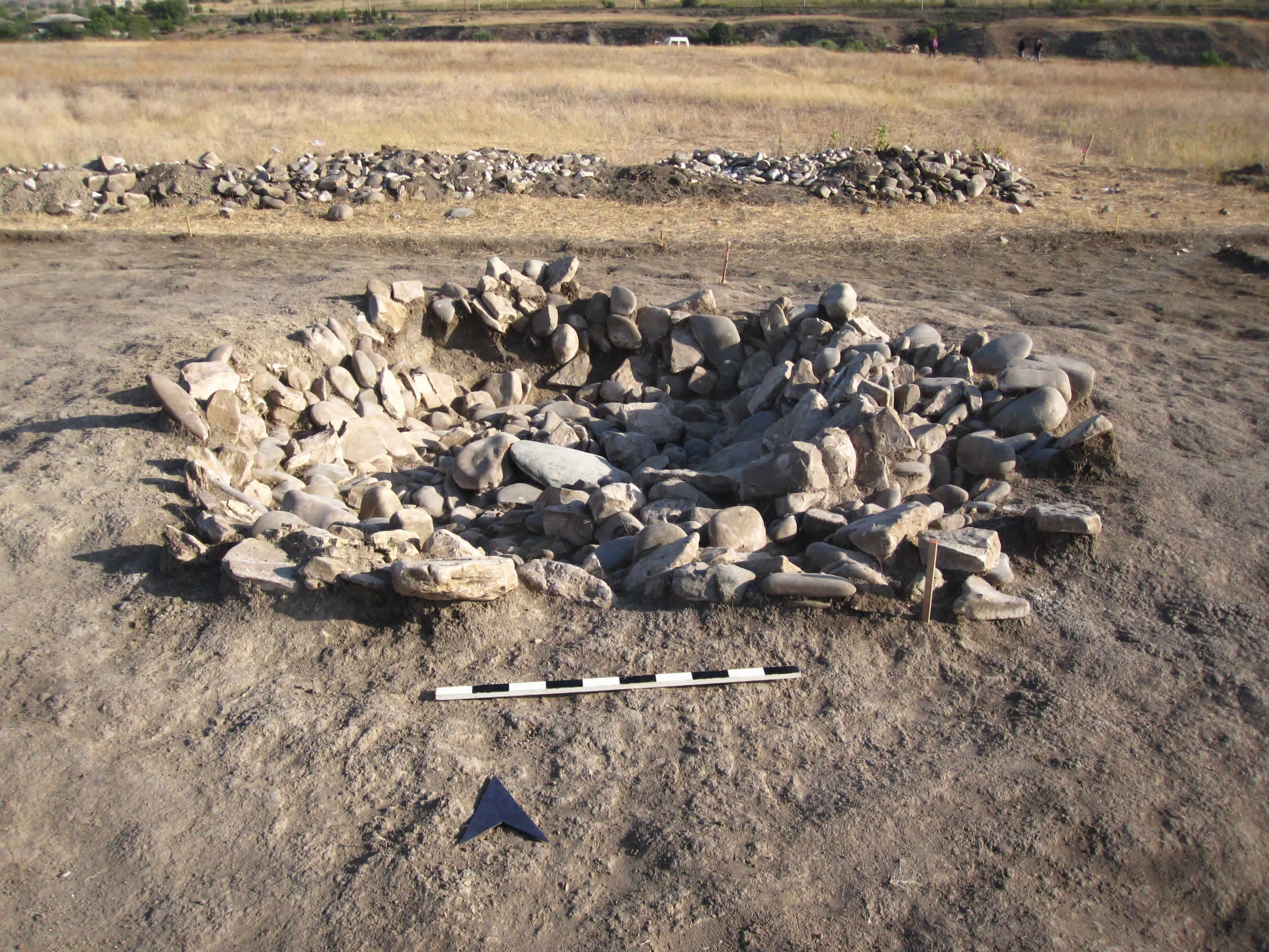
The central pit (Fig.5) had an approximately hemispherical shape; its walls had a rather irregular profile and were marked by the presence of a number of approximate “steps”. The pit was filled with different layers of stones: on the top, under the pebbles of the overlying stone mound, there was a 25-30 cm high layer of very small white and reddish river pebbles; under this, a 60-70 cm deep layer of large pebbles and flat sandstone slabs. The lowest part of the filling was formed by smaller pebbles. Except for a few fragments of decomposed animal bones, nothing was found in the pit’s filling. Interestingly enough, these bones were all found on the side of the pit, lying on one of the “steps”, under the stones. Two small pits with a diameter of 100 and respectively 150 cm cut the top of the central pit’s filling, under the kurgan’s stone mound. Both pits contained fragments of small pottery vessels of the Late Bronze Age.
A third Late Bronze Age pit was located at the NW periphery of the kurgan (Fig.6). It was also covered by the stones of the kurgan’s mound, from the outline of which is slightly projected. Its location was marked by a cluster of very large out of place white stone slabs, which might have originally belonged to some structure connected with it. The pit was ca 40 cm deep: on the top it was roughly circular and measured 120 x 150 cm, while on the bottom it was ovoid in shape, oriented in SW-NE direction, and measured 155 x 95 cm. It contained two smashed pottery jars with very typical Late Bronze combed decoration, and scattered animal bones.
Considering that no EBA finds were made in the whole kurgan’s area, it seems reasonable to conclude that the kurgan is contemporary with the above mentioned pits, and should therefore be dated to the Late Bronze Age. Its function remains rather enigmatic: it seems improbable that the central pit, the filling of which appeared to be undisturbed, contained a human burial. It would appear, therefore, that the kurgan was merely used as a site for ritual offerings. If, as it seems, kurgan no. 2 was contemporary with the neighbouring kurgans nos. 3, 4 and 5, one may suppose that it had an auxiliary function within a complex of mounds, one of which (maybe no. 5, which is definitely larger than the other ones), hosted the main burial. Another possibility is that we are dealing with an earlier (EBA?) kurgan, which was reused, after having been emptied of its original contents, during the Late Bronze Age.
Be that as it may, the presence at Okherakhevi of kurgans of both the Early and the Late Bronze Age points to a long-term continuity in the use of the site as the seat of ritual activities by the local population.
As excavated, the stone mound of kurgan no. 1 measured 10 x 4.50 m, and had a maximum height of 70 cm. It had the shape of an elongated oval, oriented in NW-SE direction (Fig.2). The kurgan had been partially damaged by modern agricultural activities on its N and S sides, and stones originally belonging to it were found scattered over an area of 14 x 9.5 m. In spite of this, it can be supposed that its original shape was already, albeit less pronouncedly, oval. The stone mound had been built on a low natural height which rose from the underlying clayish natural soil on top of the river terrace. It consisted of pebbles of small and middle dimensions, interspersed with larger slabs of whitish and yellowish sandstone, both of them from the adjacent river bed. Numerous obsidian fragments were recovered from among the stones.
A low overground chamber of squarish shape, also oriented in NW-SE direction, was located approximately in its centre. It measured 240 x 220 cm, and was ca 40 cm high; its walls were 40-50 cm wide, and were made of large flat slabs of whitish sandstone (Fig.3). The burial chamber had originally been covered with flat stone slabs of the same type, which had partially collapsed inside it due to the weight of the overlying stones. The filling of the 160 x 140 cm space inside the chamber was preserved only for ca 10 cm under the collapsed stones. It contained two smashed pottery vessels, which were both located in the northern half of the grave, in its W and respectively E part. Both were small single-handled carinated pots of fine black-coloured Bedeni pottery with corrugated shoulder and with finely incised decoration in the area of the carination. A few badly preserved fragments of human bones (among them one tooth) were found in the NE corner of the chamber. They were so few that it may be doubted that the kurgan ever contained an entire skeleton.
Kurgan no. 2 lay 85 m to the SW of kurgan no. 1, near kurgans nos. 3 and 4. Like these, it was oriented in NW-SE direction. Its stone mound measured 15 x 11 m and was 20-40 cm high, mainly composed of small-size river pebbles occasionally interspersed with larger slabs of whitish sandstone (Fig. 4). A few fragment of obsidian were recovered among the stones. These were lying directly on the underlying clayish natural soil, on what was probably originally a low natural height. A 150 cm deep pit of irregular circular shape measuring 520 x 545 cm was situated in the central part of the stone mound, and was covered by this. It was surrounded by a ca 1 m wide slightly raised ring of yellowish soil, which derived from the accumulation of the soil dug from it. Outside of this raised ring, in the northern half of the kurgan there were some traces of a possible outer ring of stones, the diameter of which may have been ca 700 cm.
The central pit (Fig.5) had an approximately hemispherical shape; its walls had a rather irregular profile and were marked by the presence of a number of approximate “steps”. The pit was filled with different layers of stones: on the top, under the pebbles of the overlying stone mound, there was a 25-30 cm high layer of very small white and reddish river pebbles; under this, a 60-70 cm deep layer of large pebbles and flat sandstone slabs. The lowest part of the filling was formed by smaller pebbles. Except for a few fragments of decomposed animal bones, nothing was found in the pit’s filling. Interestingly enough, these bones were all found on the side of the pit, lying on one of the “steps”, under the stones. Two small pits with a diameter of 100 and respectively 150 cm cut the top of the central pit’s filling, under the kurgan’s stone mound. Both pits contained fragments of small pottery vessels of the Late Bronze Age.
A third Late Bronze Age pit was located at the NW periphery of the kurgan (Fig.6). It was also covered by the stones of the kurgan’s mound, from the outline of which is slightly projected. Its location was marked by a cluster of very large out of place white stone slabs, which might have originally belonged to some structure connected with it. The pit was ca 40 cm deep: on the top it was roughly circular and measured 120 x 150 cm, while on the bottom it was ovoid in shape, oriented in SW-NE direction, and measured 155 x 95 cm. It contained two smashed pottery jars with very typical Late Bronze combed decoration, and scattered animal bones.
Considering that no EBA finds were made in the whole kurgan’s area, it seems reasonable to conclude that the kurgan is contemporary with the above mentioned pits, and should therefore be dated to the Late Bronze Age. Its function remains rather enigmatic: it seems improbable that the central pit, the filling of which appeared to be undisturbed, contained a human burial. It would appear, therefore, that the kurgan was merely used as a site for ritual offerings. If, as it seems, kurgan no. 2 was contemporary with the neighbouring kurgans nos. 3, 4 and 5, one may suppose that it had an auxiliary function within a complex of mounds, one of which (maybe no. 5, which is definitely larger than the other ones), hosted the main burial. Another possibility is that we are dealing with an earlier (EBA?) kurgan, which was reused, after having been emptied of its original contents, during the Late Bronze Age.
Be that as it may, the presence at Okherakhevi of kurgans of both the Early and the Late Bronze Age points to a long-term continuity in the use of the site as the seat of ritual activities by the local population.