ARADETIS ORGORA
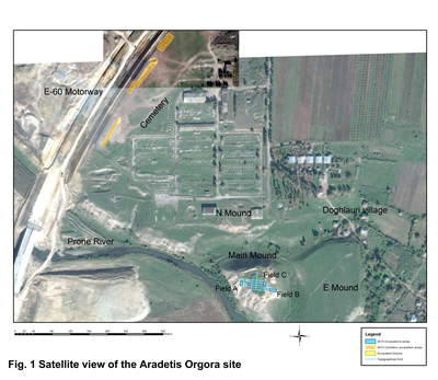
Aradetis Orgora in the Kareli district (42°02’48” N, 43°51’37”) is one of the most important archaeological site in the Shida Kartli province, and probably represented a regional centre over most of its history. The site occupies a highly strategic position on what was, and still is, one of the main communication routes in the South Caucasus, presently corresponding to the line of the modern highway crossing Georgia in the east–west direction. Located at the southern edge of the gently sloping Dedoplis Mindori plain, at the confluence of the Western Prone River and the Kura, it dominated the river plain and had easy access to the fertile soil of the adjoining terraces. The archaeological area extends over a maximal surface of c. 40 ha and includes three different mounds (the Main Mound, also known as Dedoplis Gora “the Queen’s hill”, the Northern Mound and the Eastern Mound) and a wide burial area (Doghlauri cemetery) ( Fig. 1). It was the object of sporadic human frequentation since the Paleolithic period, and continually occupied from the Late Prehistory to the Early Middle Age.
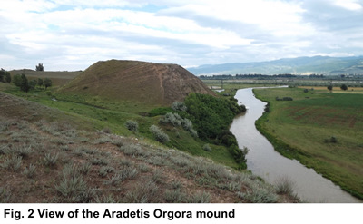
Excavations, since 2013, by the Georgian-Italian Shida Kartli Archaeological expedition focused on the Dedoplis Gora mound, a 34 m high steep-sided hill of triangular shape that dominates the Kura valley ( Fig. 2). The total depth of archaeological levels measures at least 14 meters, and consists of an almost continue sequence from the Late Chalcolithic (4th millennium BC) to the Early Middle Age (6th century AD) periods.
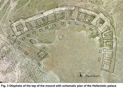
The site is presently dominated by an impressive fortified palatial building of the Late Hellenistic–Early Roman period, which probably originally occupied the whole hilltop surface (more than 3000 m2) and, due to its remarkable preservation, represents a unique example of monumental architecture of the period ( Fig. 3). Founded at the end of the 2nd or in the early 1st century BC and destroyed by an earthquake and intense fire around 80 AD, the palace at Dedoplis Gora was probably the residence of a local vassal of the king of Kartli (Caucasian Iberia), responsible for administering the royal domain in Shida Kartli. It had an irregular triangular shape, and was provided with massive corner towers of squared shape. Surrounded by an almost 3 m-wide outer wall, in which – on the ground floor at least – no windows were found, it consists of a row of rooms which open onto a large central peristyle court. The building originally had at least two storeys and was covered by a tiled roof. The rooms of the ground floor were mainly devoted to everyday activities and to the storage of less precious wares. Residential units were probably located on the upper floor(s), where luxury goods were also kept, while the central court and the peristyle were occupied by less monumental structures, mainly devoted to processing agricultural products.
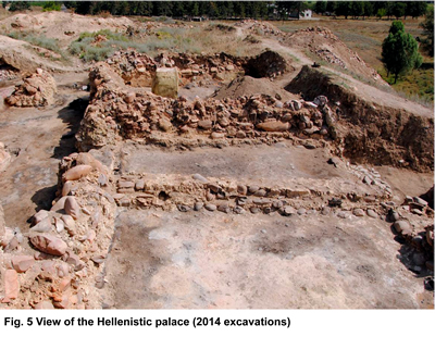
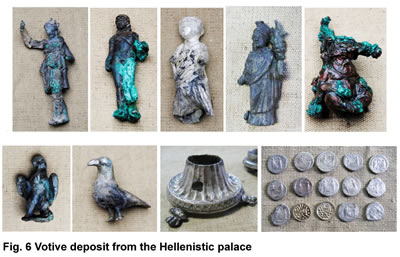
The building had previously been investigated by a Georgian team headed by Iulon Gagoshidze (1985-2007). Since 2013, excavations were resumed in the framework of the Georgian-Italian Shida Kartli Archaeological project. During the 2013-2015 seasons, three new rooms and the corresponding portion of the pillared portico were excavated ( Fig. 5). A complete, undamaged fire altar was discovered in one of these rooms, on the surface of which lay a votive deposit including bronze and silver divine figurines of, among others, Apollo, Leto, and Tyche-Fortuna, along with a silver censer, a gold ivy (?) branch, two pheasant's eggs, and a total of 15 coins ( Fig. 6). From the ruins of the palace, samples have been taken for palaeoenvironmental analyses, together with samples of building materials. A team of specialists produced a preliminary report of the building's present state of preservation, with the aim of developing an overall plan for its future preservation and promotion.
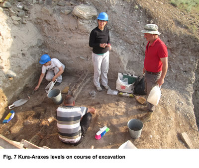
The over ten metres of pre-Classical occupation of Dedoplis Orgora had never been explored before the beginning of the joint Georgian-Italian project. The two deep soundings opened in the opposite sides of the hill have confirmed that the most important occupation phases of the site correspond to the Kura-Araxes Period (second half of the 4th-first half of the 3rd millennium BC), with a 4 meters high occupational sequence ( Fig. 7), and to the Late Bronze/Early Iron Age Periods (15th-7th centuries BC), which apparently correspond to the main phases of use of the neighbouring cemetery area. Less intensive occupation (mainly in form of sporadic material) was observed for the later Early Bronze period (Bedeni culture), while, for the first time in the Shida Kartli region, evidence for the presence of Middle Bronze Age layers (first half of the 2nd millennium BC) has been brought to light. There are also indications that the main construction episodes (re-shaping of the mound's outer limit during the Late Bronze period, erection of the Hellenistic palace) may have almost completely obliterated some of the underlying levels.
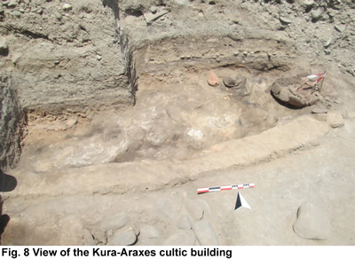
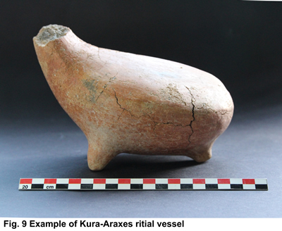
The importance of the site during the Kura-Araxes period is confirmed by the discovery, in the Eastern Sounding, of different types of architectural units (round-shaped huts with clay walls, wattle-and-daub rectilinear structures). Especially noteworthy among them is a portion of a possibly cultic building, ( Fig. 8) from the floor of which came a group of ritual vessels with zoomorphic/anthropomorphic features ( Fig. 9). The presence in the Kareli and Gori districts of a number of contemporary sites with similar features, located at regular distances from each other in the valley of the Kura River and along the courses of its main tributaries, proves that Aradetis Orgora was not an isolated case and shows that this part of the Shida Kartli region was a focus for stable and relatively intense occupation during the Kura-Araxes period.
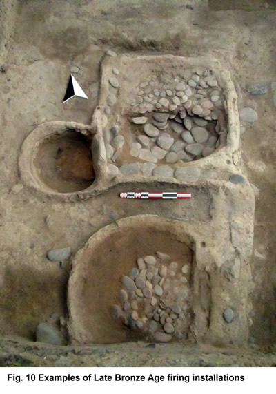
Evidence from both soundings fields proved that during the Late Bronze and the Iron Age Periods the slopes of the Dedoplis Gora mound underwent repeated episodes of re-shaping, consisting of the erection along its perimeter of massive stone walls (partially lost because of erosion), the space inside which was filled with alternating layers of river pebbles and compacted clay. Rather than being parts of a fortification system, these stone walls appear to be retaining walls, probably belonging to an extensive terracing system aimed at consolidating the mound's slope in order to create new space for the settlement, whose population was progressively growing, as also suggested by the contemporary expansion of the settlement onto the Northern and Eastern Mounds, as well as by the large number of contemporary graves discovered in the cemetery. During these phases, the excavated areas located at the periphery of the Main Mound were mainly occupied by open-air spaces, which yielded, among others, interesting examples of different types of firing installations ( Fig. 10).
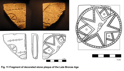
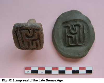
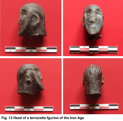
Indeed, this period was characterised by a re-settlement of the territory by a network of permanent sites and by the progressive development of structured political entities, which interacted in a increasing way with the Near-Eastern empires. The recovery, albeit in secondary contexts, of a number of significant finds from the Late Bronze and Iron Age levels (Figs. 11, 12, 13) further confirms the site's affluence during these periods and represents evidence for its regional importance and far-reaching connections.